ArcGIS Maps for Office to Brings Mapping Capabilities into Microsoft Excel and Microsoft PowerPoint
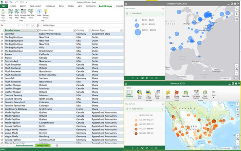
ArcGIS Maps for Office, part of the ArcGIS platform, is an add-in for Microsoft Office that brings mapping capabilities into Microsoft Excel and Microsoft PowerPoint. With ArcGIS Maps for Office, you can easily create a geospatial view of your organization’s data by creating an interactive map that includes data from Microsoft Excel and ArcGIS services—all without leaving the Microsoft Excel environment.
You can work with data stored on ArcGIS Online or behind the firewall in ArcGIS for Server, and securely access, publish, and share maps and data.

From Excel, you can share your Microsoft Excel data toArcGIS, add web maps you’ve created to Microsoft PowerPoint, or copy maps as images that can be inserted anywhere paste functionality is supported.ArcGIS Maps for Office brings mapping into Microsoft PowerPoint by allowing you to include dynamic maps from Microsoft Excel or maps from ArcGIS Online as slides within any Microsoft Excel presentation.
ArcGIS Maps for Office 4.0 includes the following new features:
- Use Smart Mapping to quickly create beautiful maps
- Find patterns in your locations over time with time-based animations
- Communicate your work more effectively with an all-new experience in PowerPoint
- Focus on the rows that are important by using map-based filtering
- Keep track of changing data by setting a refresh interval
After you install the ArcGIS Maps for Office add-in, the ArcGIS Maps tab is available in both Microsoft Excel and PowerPoint. Use this tab to interact with ArcGIS Maps for Office.
ArcGIS Maps for Office is available in 32 bit and 64 bit version of office.
Click Here to Download 60-day free trial.