Africa & Indian Ocean Region to Receive SBAS Signals
ASECNA, the Agency for Air Navigation Safety in Africa and Madagascar has launched SBAS (Satellite Based Augmentation System) services in Africa and the Indian Ocean region. It is believed that SBAS services will indeed boost flight safety and efficiency in the African airspace.
The SBAS technology supposed to extend the opportunity to deliver services in large areas that are not served by airlines at present. These areas lack local air navigation infrastructure, and SBAS technology supposed to provide navigation services in these areas without the need for local navigation infrastructure.
The first essential step of our SBAS services provision plan, the broadcasting tests for pre-operational service was started last August.
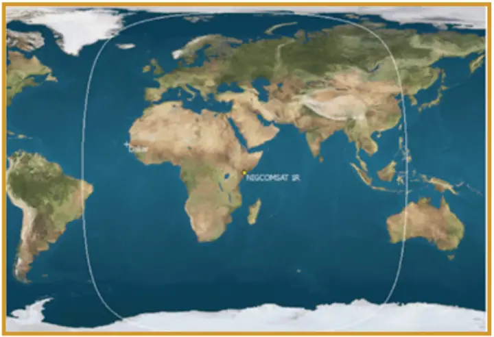
The initial service was supported by infrastructure deployed the Thales Alenia Space company and of its Nigerian partner Nigcomsat LTD. The infrastructure is composed of the SAGAIE GNSS stations network, a demonstrator, an uplink station, and the GEO satellite NigComSat-1R.
The main objectives are to carry-out technical trials, to undertake field demonstrations for aircraft and rotorcraft. The system is also supposed to provide additional services such as Precise Point Positioning (PPP) and Emergency Warning Services to populations (EWS).
The Operating Principle
This SBAS system will be using GNSS core constellations such as GPS and GALILEO for computing and broadcasting correction messages to the users (aircraft).
Since GNSS core constellations have limitations especially with vertical accuracy and the availability of satellites. They do not guarantee the positioning, nor do they alert users in case of errors.
So, GNSS core constellations therefore only used for horizontal navigation operations, from en-route down to non-precision approaches, for which only lateral guidance is provided.
Augmented positioning with SBAS provides better horizontal guidance, but also and more importantly vertical guidance. The combined accurate – horizontal and vertical positional information is used for more advanced navigation operations such as precision approaches, equivalent to ILS CAT-I.
Instrument Landing System (ILS) is used in airline navigation. ILS is defined as a precision runway approach aid based on two radio beams which together provide pilots with both vertical and horizontal guidance during an approach to land.
SBAS correction messages are computed by a ground segment (dedicated processing and check-set systems in the Mission Control Centres (MCC), using the GPS and GALILEO constellations data collected by a network of reference stations and transmitted to the space segment via the uplink stations) and broadcasted to every aircraft in the service areas through one or several geostationary satellites, which constitutes the space segment.
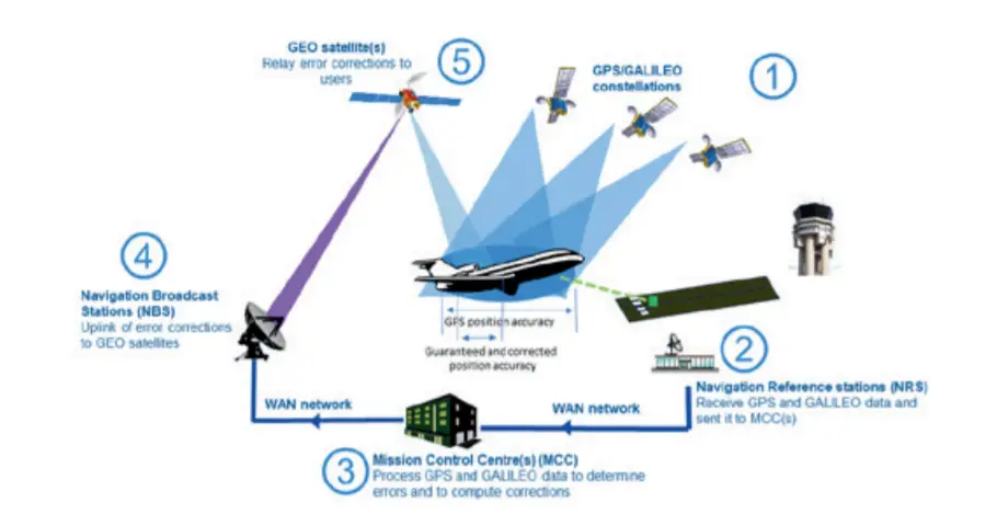
Dedicated and advanced correction algorithms have been developed to apply the ionosphere correction in the equatorial region. The equatorial region has a specific dynamic compared to high and mid-latitudes, leading to perturbations of GPS and GALILEO signals propagation.
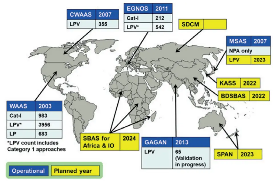
Other Operating SBAS System in the World
There are many satellite-based augmentation systems working across the globe. Given is a list of operation SBAS systems in the world –
- Wide Area Augmentation System (WAAS) – USA
- European Geostationary Navigation Overlay Service (EGNOS) – Europe
- MTSAT Satellite Augmentation System (MSAS) – Japan
- GPS Aided GEO Augmented Navigation (GAGAN) – India
- System for Differential Corrections and Monitoring (SDCM) – Russia
- BeiDou Satellite-Based Augmentation System (BDSBAS) – China
- Augmentation Satellite System (KASS) – Korea
- SBAS for Africa & Indian Ocean – Africa
- Southern Positioning Augmentation Network (SPAN) – Australia/ New Zealand
More about GAGAN can be read at following links –
- http://www.gisresources.com/gagan-system-certified-rnp0-1-operations/
- https://www.gisresources.com/gagan-will-become-fully-operational-february/
- https://www.gisresources.com/dgca-airlines-use-gagan-face-consequence/