
Posts From GIS Resources
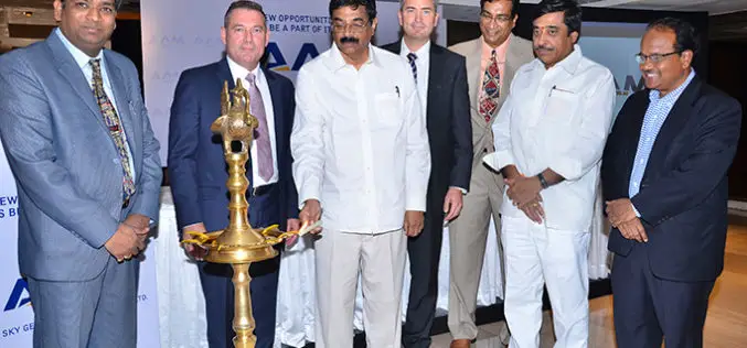
AAM Expands into India to Create AAM India
AAM officially announced its expansion into India in New Delhi on 18 May 2015. At a ceremony held in the city, AAM Group entered a partnership with Mr. Srinivasa Murthy

OGC Announces Geospatial/BIM/Indoor Location Workshop
18 May 2015 – The Open Geospatial Consortium (OGC®) announces a Geospatial/BIM/Indoor Location (“GIS BIM”) Workshop to be held at the UCAR/NCAR Center Green in Boulder, Colorado on Tuesday, 2

Geo-matching.com Adds Big Data Management Systems Category
Lemmer, 19May 2015– Geo-matching.com has recently added Big Data Management Systems to its broad spectrum of product categories. MEIXNER IMAGING is the first supplier in this category. In addition to general specifications,detailed information

Rajendra Mani Tripathi – The New Surveyor General of India
Rajendra Mani Tripathi has taken over the charge of Surveyor General of India with effect from May 01, 2015, succeeding Dr Swarna Subba Rao. The Surveyor General of India is the Head of

India and Vietnam to Cooperate in Earth Observation Technology
In a recent visit by the delegation of the Vietnamese ministry to India, a joint decision between India’s Ministry of External Affairs, Department of Space, and Space Research Organisation and

ESA and Airbus Defence and Space sign Contract for New Copernicus Earth Observation Mission
Jason-CS/Sentinel-6 keeps its eye on the oceans’ surface topography New Copernicus satellite scheduled for launch in 2020 At the 36th International Symposium on Remote Sensing of Environment in Berlin, the European
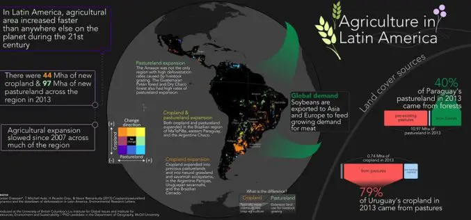
Remote Sensing to Study Dynamics of Cropland in Latin America
In a study, “Cropland/pastureland dynamics and the slowdown of deforestation in Latin America,” published in Environmental Research Letters by Jordan Graesser and et. al., brings out some interesting facts about

OGC Announces Water Data Summit
The Open Geospatial Consortium (OGC®) announces a Water Data Summit to be held at the UCAR/NCAR Center Green in Boulder, Colorado on June 3, 2015. This event is part of

Changing Hands at Cadcorp
The leadership team at GIS software vendor Cadcorp has successfully completed a management buyout (MBO) of the company. The MBO secures the business’ future as one of the UK’s leading

Disaster Management Plan for Chennai to be Ready Soon
According to recent news by The Hindu, the Commissioner of Revenue Administration in association with Chennai Corporation and Chennai district collectorate will work together on disaster management. Chennai is yet
