
Posts From GIS Resources

Upcoming Changes to USGS ESPA Processing and Output options of Surface Reflectance Climate Data
Today I received an email from USGS as a notice of changes coming soon to the USGS EROS Science Processing Architecture (ESPA) interface (https://espa.cr.usgs.gov/) , that allows you to process Landsat 4/5 Thematic

China Distributes Millions of Controversial Maps to Troops
Beijing: China is distributing millions of controversial updated maps to its military in the first upgrade in 30 years, reportedly reinforcing its claims over Arunachal Pradesh. All major army units will

Ordnance Survey Innovation Team Supports Young Programmers in Annual Festival of Code
Young people from across the Solent area, with a keen eye for coding are being urged to sign up to a national coding competition this summer between 28 July and

Earth Station on Brazilian Land to get Data from IRS
In recent news, Prime Minister’s Office has informed that India and Brazil on Wednesday signed an agreement in Brasilia on cooperation in augmentation of a Brazilian earth station for receiving and
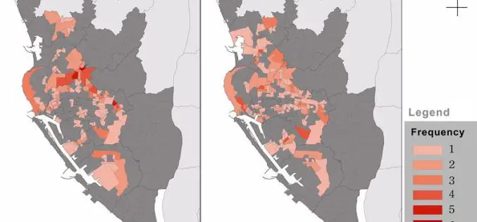
Dengue Fever Control and Prevention via GIS Technologies
Controlling and preventing infectious diseases like dengue fever is one of the main issues for public health authorities in many countries. GIS technologies can play a key role to support

York University Offering Certificate Courses in Remote Sensing
York University is helping to shape the global thinkers and thinking that will define tomorrow. York is Canada’s third largest university with a commitment to excellence which reflects a rich
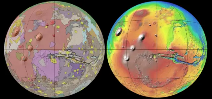
New Global Geologic Map of Mars
Understanding the Past to Enable Future Exploration A new global geologic map of Mars –the most thorough representation of the “Red Planet’s” surface – has been published by the U.S.

Pooch-O App to Book Delhi’s GPS Enanled Auto-rickshaws
“Poocho-O” an Android app was launched today by Delhi’s Lt. Governer Najeeb Jung. Delhi Intergrated Multi-Model Transit System (DIMTS) has developed “Pooch-O”. The app will enable commutators to use their

Free Climate Data for Germany of the Climate Data centre
The Deutscher Wetterdienst (DWD) makes available the whole collection of climate data it acquires, processes and archives. The CDC offers accesss to climate data for Germany, but also to data with

University of North Alabama Offers Online GIS Analyst Certificate Program
University of North Alabama Offers Online GIS Analyst Certificate Program consisting of five courses that will be completed in 9 months (September 16, 2014 – May 28, 2015). The five courses
