
Posts From GIS Resources

RFP: Detailed Survey for the Construction of 400kV DC Evacuation Line for a Distance of about 20Km in Bellary District.
Karnataka Power Transmission Corporation Limited has invited tender for “Conducting the detailed survey for the construction of 400kV DC Evacuation line, with QUAD Moose Conductor from 400kV ETPS Pooling station to proposed
Esri Geospatial Technology Speeds Analysis for US Army
Ready-to-Use Templates Quickly Deliver Critical Information to the Field April 7, 2014-Redlands, California—Esri has provided a recently revised set of customized templates to the US Army for its Distributed Common Ground

Remote Sensing to Search Minerals for Turkey and Azerbaijan
In recent news, Turkey and Azerbaijan have started a joint program to explore mineral deposits using earth observation satellites. As per the agreement Turkey will build a Remote Sensing laboratory

SuperGIS 3D Earth Server 3.2 Officially Launched
Supergeo Technologies, the leading global provider of complete GIS software and solutions, officially released SuperGIS 3D Earth Server 3.2, to assist enterprises in managing, integrating, publishing and displaying geographic data
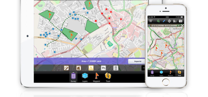
Comsoft Paris Uses SuperSurv 3 to Extend Enterprise Solutions
Supergeo Technologies, the leading global provider of complete GIS software and solutions, announced that Comsoft Paris selected SuperSurv, the data collection app for Android and iOS platforms, to extend business

Remote Sensing and Earth Observation Fields Webinar – NSW
The webinar aims to bring together people who are working in the remote sensing and earth observation fields to hear how these professionals are using earth observation data for their

GeoMax Zipp10 Pro With Handy New Additions to the Entry Level Total Station
GeoMax has introduced some first class improvements to the Zipp10 Pro Total Station Series, designed to make sure the data you need is always at hand. A USB port and
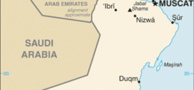
New GIS Smartphone App Launched by NCSI at COMEX 2014
Muscat | 6 April, 2014 – The COMEX 2014 exhibition, which opened its doors at Oman International Exhibition Centre on April 7, features a comprehensive presence from The National Centre for

The International Space Apps Challenge
The International Space Apps Challenge is an international mass collaboration focused on space exploration that takes place over 48-hours in cities around the world. The event embraces collaborative problem solving
Understanding Shapefile (.shp) File Format
Shapefile is a vector data format for storing geographical data and associated attribute information. It is developed and regulated by Esri as open specification for data interoperability among Esri and other GIS software products. Shapefile
