
Posts From GIS Resources

Workshop on Satellite Remote Sensing and Applications at UNSW, Australia
Free Workshop on Satellite Remote Sensing and Applications-For UNSW Undergraduate and Postgraduate Students This FREE two-day workshop for UNSW undergraduate and postgraduate students will discuss: the principles of satellite remote
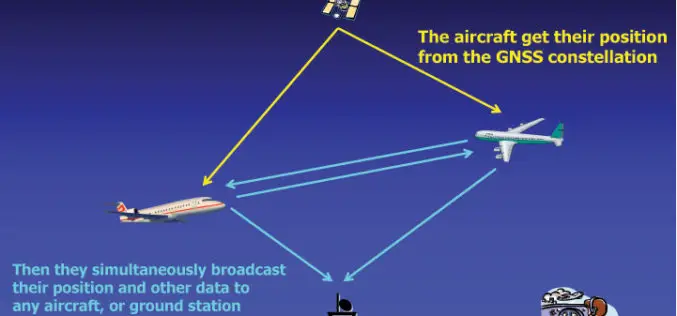
U.S.: By 2020 All Aircraft Must Have GPS Tracking System
In recent news, in take way from recent incident of mysterious disappearance of Malaysian Airlines plane MH 370, The Federal Aviation Administration (FAA) is accelerating the implementation of a system

Scientists Chart Seafloor of One of Earth’s Largest Marine Protected Areas
Apr 15, 2014- On April 11, scientists returned from a 36-day mapping expedition to Papahānaumokuākea Marine National Monument (PMNM) in the remote Northwestern Hawaiian Islands. PMNM is the largest protected area
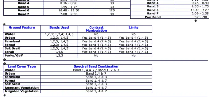
Band Combination of Landsat Thematic Mapper
The PDF will give detail information about band combination information in detail for Landsat Thematic Mapper Satellite. Download Band Combination

BAE Systems Unveils Geospatial Intelligence Mobile App for Google Glass
BAE Systems today unveiled a new mobile app that can be used with Google Glass for hands-free geospatial intelligence data collection and photo reporting from anywhere in the field. Apr

Digimap for Schools Launches Historic Maps of Great Britain
Digimap for Schools has added a new historic map layer to the popular online map service, extending its potential for use in schools across a wider spectrum of the national

PR: Trimble Delivers 3D Scanning Extension for SketchUp
New Tool Allows Easy Creation of Visual 3D Models from Real-World Scanning Data COLORADO SPRINGS, Colo., April 14, 2014—Trimble (NASDAQ:TRMB) announced today the release of Trimble® Scan Explorer Extension
Trimble Announces New Software Updates to Simplify Geospatial Analysis and Modeling
Advanced Productivity When Working with Images and Scan Data COLORADO SPRINGS, Colo., April 14, 2014—Trimble (NASDAQ:TRMB) announced today comprehensive updates to its powerful suite of geospatial office software, including Trimble®

IIT Hyderabad is Inviting Application for Ph.D. Programme
IIT Hyderabad is part of history in the making. We, the faculty, students and staff are creating a new institute, an institute, which in due course of time will make
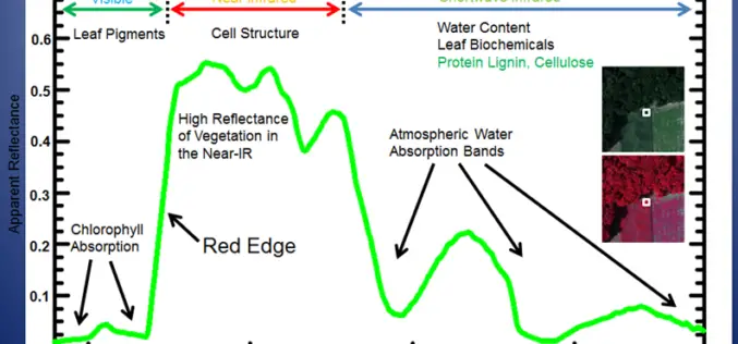
Why does NDVI, NDBI, NDWI Ranges From -1 to 1?
The indices calculated from satellite imageries such as the Normalized Difference Vegetation Index (NDVI), Normalized Difference Built Index (NDBI) and Normalized Difference Water Index (NDWI) have indices values ranging from
