
GIS

Uttar Pradesh Goes for GIS Mapping of Minor Irrigation Constructions
According to recent news by ToI, the Minister for Minor irrigation, Groundwater, Animal husbandry and Panchayati Raj Mr. Raj Kishore Singh of Uttar Pradesh has directed that GIS mapping of construction
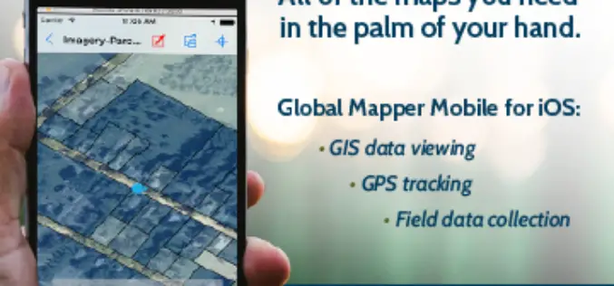
Global Mapper Mobile is Now Available for iOS
Blue Marble Geographics are pleased to announce the immediate availability of Global Mapper Mobile for iOS, a field-optimized version of the desktop software. Global Mapper Mobile offers powerful GIS data

Great Day in Indian Space History With the Launch of 20 Satellites in a Single Mission
In its thirty sixth flight (PSLV-C34), ISRO’s Polar Satellite Launch Vehicle successfully launched the 727.5 kg Cartosat-2 Series Satellite along with 19 co-passenger satellites on June 22, 2016 from Satish

Abu Dhabi Municipality Launches GIS Platform for Submittal of Road Layout Data
In a major boost and expansion to the e-services, The Abu Dhabi City Municipality (ADM) has launched a platform that allows submittal of roads layout data standards using Geographic Information
Iranian Space Agency to Put Indigenous Satellite in Orbit by 2025
According to recent news by MNA – ISA deputy director has announced Iran’s ultimate goal as building indigenous satellites parallel to foreign models and to place them into geosynchronous equatorial

Isro to Launch Cartosat-2 Series Satellite Mission : Scheduled on June 22, 2016
India’s Polar Satellite Launch Vehicle, in its thirty sixth flight (PSLV-C34), will launch the 727.5 kg Cartosat-2 series satellite for earth observation and 19 co-passenger satellites together weighing about 560 kg
Passive and Active Remote Sensing Technology Market Forecast Report – 2015 – 2022
Research Corridor recently added new report titled “Passive and Active Remote Sensing Technology Market – Global Trends, Market Share, Industry Size, Growth, Opportunities, and Market Forecast – 2015 – 2022”

Govt May Review Provisions of Geospatial Bill: India
New Delhi, (PTI) Government may review some of the provisions of a draft bill that proposes jail term of seven years and a fine up to Rs 100 crore if

Kenya to Launch Aerial Survey of Minerals
According to recent news by the Standard Digital, Kenya will be launching an aerial survey to map out its minerals following a budgetary allocation of Sh 3 billion in the 2016-2017

Indonesia Using Geoportal to Monitor the Condition of Public Infrastructure
The Ministry of Public Works and Public Housing’s Institute of Road Engineering, Agency for Research and Development (Pusjatan) has unveiled a new smart mapping portal called Geoportal Pusjatan, which was
