
GIS
New ASPRS Positional Accuracy Standards for Digital Geospatial Data Released
The American Society for Photogrammetry and Remote Sensing (ASPRS) is pleased to announce the release of the new Positional Accuracy Standards for Digital Geospatial Data. The new standards are available

Ordnance Survey to Open Hub Dedicated to Innovation
In a move that aims to energise innovation in the UK geospatial industry, Ordnance Survey is opening a London-based Geospatial Innovation Hub to attract new players, new visions, new thinking and

Railways to Digitize Mapping of Land Records to Counter Encroachment of Railways Land
The Union Railway Minister Shri Suresh Prabhakar Prabhu has said that encroachment on the Railway Land is a serious issue and to counter this, digitized mapping of land records has

Supergeo Renews Partnership with Star Vision for GIS Development in Southeast China
Supergeo Technologies, the global leading GIS software and solution provider, announced the extended partnership with Star Vision, the professional GIS consulting and surveying firm in Hong Kong, to further develop
To Drive Economic Growth and Digital Innovation through Open Data
To coincide with International Open Data Day, when countries across the globe will show their support for open data policies, Ordnance Survey (OS) announce plans to launch a world-leading digital map
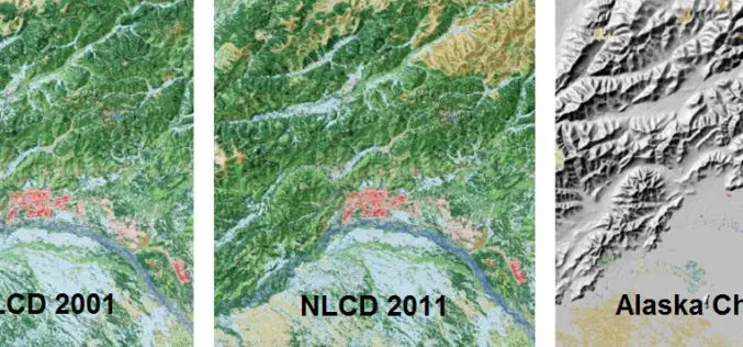
A Decade of Change in America’s Arctic: New Land Cover Data Released for Alaska
The latest edition of the National Land Cover Dataset (NLCD 2011) for Alaska is now publicly available. The extensive NLCD database continues to add to our understanding of where land

New Esri Book Applies the Science of GIS to Literature, History, and Culture
Maps created using geographic information system (GIS) technology can be used to explore and interpret events in literature, history, and culture. That’s the premise of Abstract Machine: Humanities GIS, a

DOT and FAA Propose New Rules for Small Unmanned Aircraft Systems
Regulations Will Facilitate Integration of Small UAS into U.S. Aviation System Washington – The Department of Transportation’s Federal Aviation Administration today proposed a framework of regulations that would allow routine

Digital Aerial Solutions Expands Mapping Services with Purchase of Leica ALS80 Laser Scanner
Leica Geosystems Inc. today announced that Digital Aerial Solutions (DAS), a woman-owned small business based in Tampa, Fla., is the first company in North America to purchase the ALS80 laser

Ministry of Interior Achieves Best International Standards in Geospatial Information Security
The Geographic Information Systems, GIS, Security Centre at Abu Dhabi has achieved a new accomplishment for the Ministry of Interior, MoI, through receiving accreditation from the Open Geospatial Consortium, OGC,
