
Global Positioning System
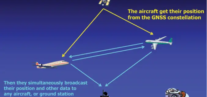
U.S.: By 2020 All Aircraft Must Have GPS Tracking System
In recent news, in take way from recent incident of mysterious disappearance of Malaysian Airlines plane MH 370, The Federal Aviation Administration (FAA) is accelerating the implementation of a system

India’s PSLV-C24 Lifted off Sucessfully IRNSS-1B Spacecraft
The PSLV-C24 lifted off at 17:14 hrs (IST) on board with IRNSS-1B spacecraft. IRNSS-1B is the second satellite of India’s national programme Indian Regional Navigation Satellite System (IRNSS). IRNSS system will

New Airborne GPS Technology to Predict Hurricanes
A new GPS system aboard airplanes can improve hurricane forecasting and weather models by detecting precise conditions in the atmosphere, scientists say. Current measurement systems that use Global Positioning System
GPS Tracking to Combat Domestic Violence
REPEAT domestic violence offenders could be strapped with GPS tracking bracelets and forced to foot the bill under a NSW government proposal. NSW Community Services and Family Minister Pru Goward

South Delhi Municipal Corporation to Use Geo-spatial Technologies for Waste Management
In recent news, South Delhi Municipal Corporation (SDMC) is planning to use geo-spatial technology for monitoring and implementation of waste management in municipal corporation area. The sanitation action plan includes GPS-tracked garbage

NOAA’s National Geodetic Survey : 2014 GPS on Bench Marks Campaign
NGS encourages anyone with survey-grade Global Positioning System (GPS) receivers to join the 2014 GPS on Bench Marks Campaign, a National Surveyors Week (March 16-22) event to raise awareness about professional surveying

Built-in GPS for Mercedes Benz Owners to Locate Their Car with Smartphone
In a recent news, Mercedes Benz comes with a similar technology as of Apple’s ‘Find My iPhone’ which uses the device built-in GPS Sensor to locate their smartphone. The technology
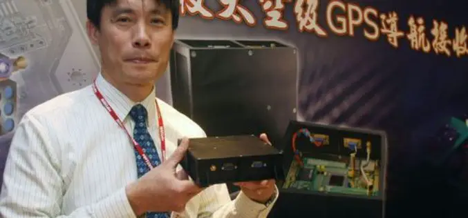
Taiwan Develops its First Space Based GPS Receiver
In recent news, scientists in Taiwan have developed the nation’s first space-based Global Positioning System (GPS) receiver, detraction in the country’s reliance on foreign imports. “The first locally developed space-borne
Must have GPS Installed on all Vehicles by February 20
Ministry of Road Transport and Highways issued guidelines that owners of public service vehicles of cities with a population of over 10 lakh are required to get GPS (Global Positioning

GPS Navigation & Maps (light) Now for Android Devices
The global success for iPhone & iPad (more than 3.5 million users: GPS Navigation 2) now finally available for Android devices. With GPS Navigation & Maps you need worry no
