Conducting Flood Hazard and Risk Mapping For the Complex Evros River Basin
Z&A P. Antonaropoulos & Associates S.A. designed flood hazard and flood risk maps for the Greek part of the Evros River Basin after completing our MIKE FLOOD training course.
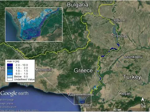
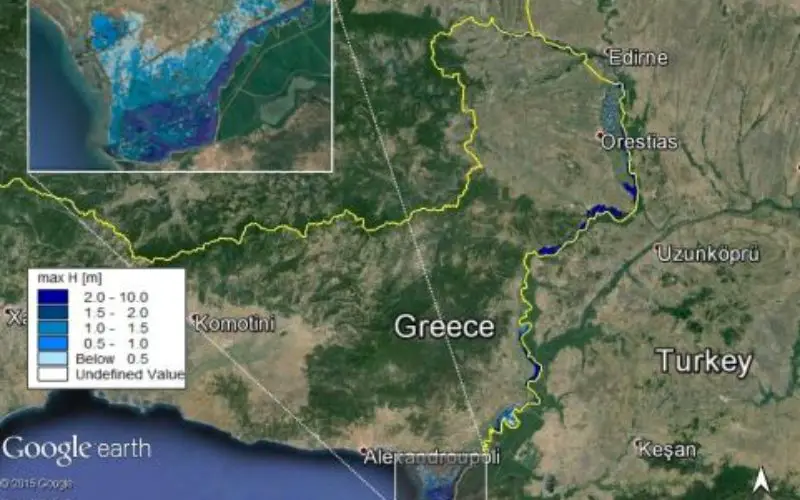
Basic scenario results of the Evros River and detail of delta inundation for 100 years recurrence interval. Data: SIO, NOAA, U.S. Navy, NGA,
GEBCO ©2015 Basarasoft ©2015 Google
The Evros River Basin covers an area of 53,000 km2 in the southeast of the Balkan Peninsula and is shared by Bulgaria, Turkey, and Greece. At 528 km, the Evros River is the second longest river in the Balkans. Through the years, catastrophic flood events have occurred along the approximately 200 km of the river that borders Greece and Turkey.
To decrease the risk of flooding along the Evros River, Z&A P. Antonaropoulos & Associates S.A. (the lead on a Greek consortium developing the Flood Risk Management Plan for the Greek part of the Evros River Basin) took a MIKE FLOOD training course.
Using their excellent knowledge of the physical system and what they learned from the course – in addition to support provided by DHI throughout the project – Z&A designed flood hazard and flood risk maps for the Greek part of the Evros River Basin.
Z&A calibrated the model so that it correctly reflected the extent of the historical 12 February 2010 flood. They utilised 115 low altitude aerial photographs, kindly provided by the Alexandroupolis Aero Club, to identify landmarks and characteristic points on the ground as well as map flooded areas on satellite photographs in order to qualitatively validate the results of the MIKE FLOOD model. Basic and alternative hydrological scenarios were then simulated for the Evros and Ardas Rivers for different recurrence intervals.
The flood risk analysis and mapping for the Greek part of Evros River Basin revealed that thousands of people, several kilometres of road, several irrigation and drainage pumping stations, and two environmentally protected areas could be affected by both river flooding and sea level rise in the future.
Using this information, the Flood Risk Management Plan will be prepared, taking into account potential embankment failures. As the first milestone towards implementation of European Union Flood Directive 2007/60/EC in Greece, the plan will help the country mitigate the effects of flooding along the Evros River.
Source: The Academy by DHI