Enhancing Tectonic Studies with Machine Learning For Crustal Velocity Prediction
Crustal deformation is a critical area of study, especially in tectonically active regions like the Tibetan Plateau. In their research, Bappa Mukherjee, et. al. present a novel approach using machine learning for crustal velocity prediction, leveraging GPS data from a network of Continuously Operating Reference Stations (CORS). These CORS stations provide essential positional data for geodetic studies, allowing scientists to measure tectonic shifts.
However, the limitations in the coverage of CORS data have made it challenging to comprehensively analyze tectonic movements, especially in remote areas. Machine learning (ML) models offer a powerful solution to fill this gap by predicting crustal velocity vectors in regions with sparse CORS data.
Importance of the Study
Understanding tectonic processes in the Tibetan Plateau is crucial for evaluating seismic risks, especially in the Indian subcontinent. The Indo-Eurasian collision zone causes ongoing crustal deformation, with significant implications for earthquake prediction and infrastructure resilience in northern India and nearby regions. CORS networks play a fundamental role in collecting the necessary GPS data, but due to logistical challenges, these networks are often sparse in difficult terrains.
This study integrates CORS data and machine learning for crustal velocity prediction, providing a scalable and cost-effective solution to monitor tectonic shifts. The ability to predict velocity vectors where CORS data is lacking can improve seismic hazard assessments and overall geodetic modeling.
Also Read – Towards Earthquake Early Warning Systems: Insights from Satellite Data on the 2023 Türkiye Earthquake
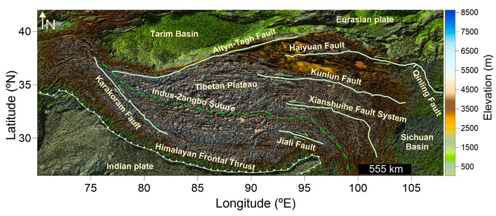
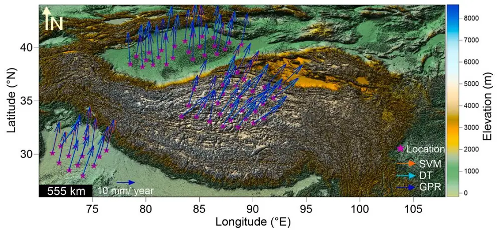
Geology of the Study Area
The Tibetan Plateau, spanning over 2.5 million square kilometers, is known for its complex tectonic processes. The plateau’s uplift and subsidence are a direct result of the ongoing collision between the Indian and Eurasian plates. This region, referred to as the “Roof of the World,” is critical for studying crustal deformation. By integrating CORS data and machine learning for crustal velocity prediction, the researchers provide valuable insights into the tectonic shifts shaping the plateau.
Data Used in the Analysis
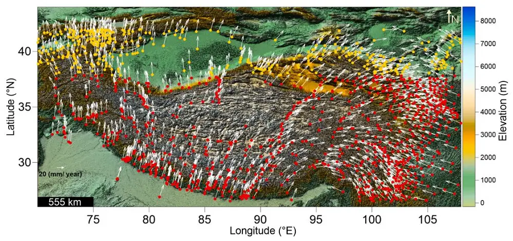
The study utilized velocity data from 1,271 GPS stations, including both continuous and campaign-mode data. A significant portion of this data comes from CORS networks, which offer precise, continuous monitoring of tectonic shifts. CORS stations capture both Easting (VE) and Northing (VN) velocities, forming the basis for machine learning models used in this study.
The data was processed using PANDA software, which transformed the GPS data into a Eurasia-fixed reference frame. The combination of CORS data and machine learning allowed for accurate crustal velocity predictions in regions with sparse GPS coverage.
Methodology: Combining CORS Data and Machine Learning for Crustal Velocity Prediction
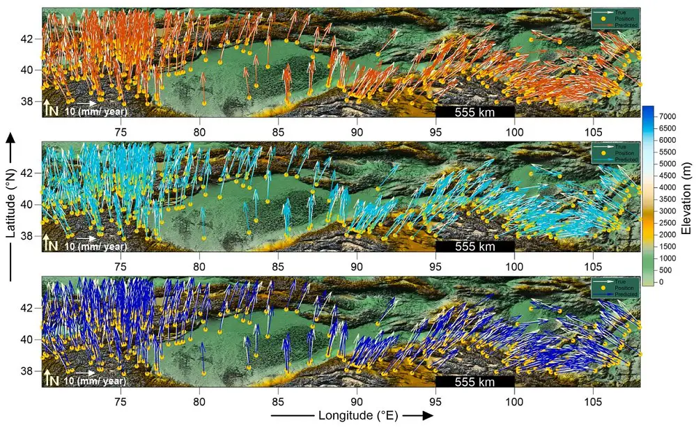
The study applied three machine learning algorithms – Support Vector Regression (SVR), Decision Tree (DT), and Gaussian Process Regression (GPR) – to predict crustal velocity vectors. Training data from 891 GPS stations and test data from 380 stations were used to train the models. The goal was to predict velocity vectors for locations with limited CORS data coverage.
The models utilized CORS data as a training foundation, allowing them to capture the intricate spatial-temporal relationships between GPS station locations and tectonic movements. The SVR model used kernel functions to handle nonlinear data relationships, while the decision tree algorithm divided the input space into regions based on data patterns. The GPR model added a probabilistic element, allowing for uncertainty in predictions.
Results and Visual Analysis
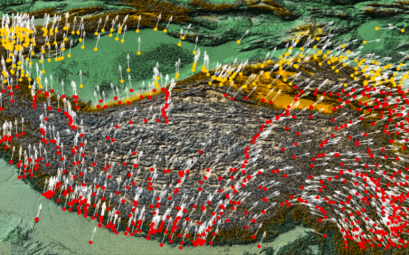
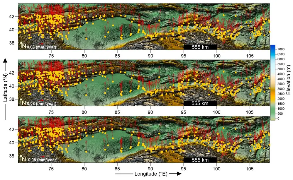
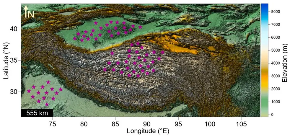
The machine learning models performed exceptionally well, with correlation coefficients exceeding 0.96 during testing. This demonstrated the ability of machine learning for crustal velocity prediction to complement CORS data. The models generated velocity vector maps for both test GPS stations and virtual stations where CORS coverage was insufficient.
The visual analysis provided in the study includes overlay plots comparing actual and predicted velocity vectors, which illustrate the accuracy of the models. These visualizations confirm that the ML models can accurately replicate the results derived from CORS data.
Future Implications and Limitations
While the integration of CORS data and machine learning for crustal velocity prediction is promising, the study acknowledges a few limitations. First, the accuracy of predictions depends on the quality and availability of CORS data, especially in remote areas. In regions with sparse CORS coverage, the performance of the models may be constrained. Future research could improve prediction accuracy by incorporating additional geophysical features such as fault data and seismic activity.
Additionally, real-time updates from CORS networks and campaign-mode GPS stations could enhance the models’ ability to predict tectonic movements in dynamic regions. Another promising avenue is the use of transfer learning, where pre-trained models from similar terrains could be fine-tuned for specific regions.
Conclusion
This study by Mukherjee, Gautam, and Sain demonstrates how combining CORS data and machine learning for crustal velocity prediction can enhance geodetic studies, particularly in tectonically active regions like the Tibetan Plateau. By integrating CORS data with machine learning models, the researchers were able to accurately predict crustal velocity vectors, offering a cost-effective solution for monitoring tectonic shifts. This approach has broad implications for improving seismic risk assessments and geodetic analyses across the Indian subcontinent.
References
Mukherjee, B., Gautam, P.K., & Sain, K. (2024). Machine Learning Assisted Crustal Velocity Proxy: A Case Study Over the Tibetan Plateau and its Surroundings. Journal of Asian Earth Sciences, 263, 106004.