Redlands, California—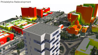 This provides urban planners, designers, and citizens easy to understand intelligence for improving their cities.
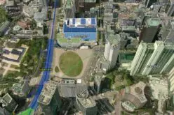
ArcGIS provides deep insight into an urban scenario while CityEngine creates realistic digital 3D models. Now designers can create a shape on a CityEngine model, export that shape into ArcGIS, and then use powerful analytical tools to evaluate the impact the proposed building will have on the city.
ArcGIS allows planners to see how the building would cast its shadow at different times of the day throughout the year. They can study the view of the building within the context of other nearby structures and measure the amount of sky that can still be seen. They can also analyze solar exposure for solar energy or locate potential heat corridors.
Designers can easily share their models online with stakeholders or the public by creating CityEngine web scenes. A web scene is an interactive 3D version of a web map. It is sent with a web viewer so the end user does not need additional software. The designer uploads the web scene to the Esri ArcGIS Online platform or to a proprietary server and then shares the URL with anyone.
CityEngine web scenes are very helpful for proposing structures and encouraging community feedback. Anyone with a WebGL-enabled browser can immediately interact with the web scene. End users can fly around a 3D city, through streets, around buildings, and overhead to see the scenario from every angle. They can also turn on and off scene layers to see a proposed building, a street with or without trees, and more. A sunlight impact tool shows where a proposed building will cast a shadow at what time of year, during different times of the day, and for how long. Esri ArcGIS analytic tools and CityEngine bring vision to planning.
CityEngine is available for the Windows, Mac, and Linux platforms. Learn more about CityEngine and sign up for a free 30-day trial at esri.com/cityengine.
# # #
Press Information:
Barbara Shields, Esri
Tel.: 909-793-2853, extension 1-2641
E-mail (press only): press@esri.com
General Information: info@esri.com