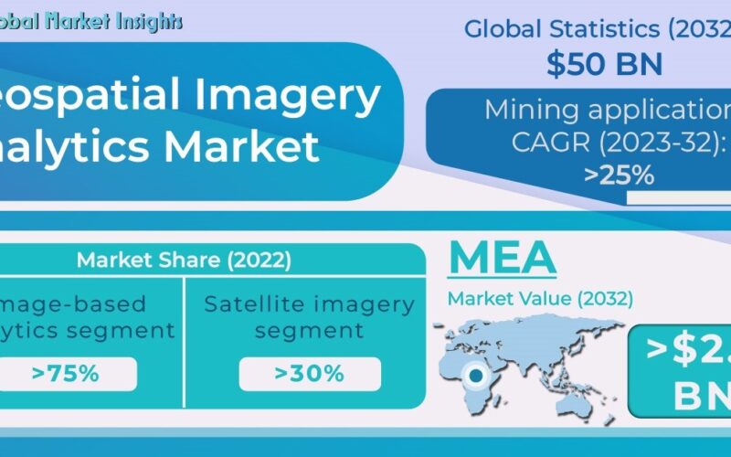
As per a recent industry report put forward by Global Market Insights, Inc. Geospatial Imagery Analytics Market is forecast to register its name in the billion-dollar fraternity down the line of seven years, by exceeding a revenue of USD 50 billion by 2032 with a projected CAGR of 20% over 2023-2032.
The market growth is owing to the rising traction of location-based applications, such as customer analytics, retail site selection, expansion planning, sales territory design, and supply chain management. In addition, the leading location-based service providers are collaborating with tech companies to augment the analytical capabilities of their location-based solutions, which will add to the market growth over the coming years.
Although, the geospatial imagery analytics market is expected to face hindrances in the coming years as geospatial imagery analytics systems are made up of highly complex map structures that are difficult to deploy with traditional maps to gain meaningful insights. However, mounting demand for communication services from deaf and speech-impaired individuals is anticipated to grow, which is likely to add impetus to the industry expansion. Besides, several government agencies are supporting the telecommunications relay service providers by offering significant relaxations, further transforming the market outlook.

Overall, the geospatial imagery analytics industry is segmented in terms of analytics type, deployment model, collection medium, application, and region.
Based on analytics type, the geospatial imagery analytics market from the image-based analytics segment is expected to register massive growth during 2023-2032, driven by the growing adoption of geospatial technologies such as geographic information systems (GIS) and positioning systems. In addition, the geospatial imagery service providers are also constantly using surveillance cameras and drones to evaluate the video content to improve quality, which is further slated to result in segmental expansion.
Considering the deployment model, the on-premises segment would grow profusely by 2032 end. The on-premises deployment model empowers enterprises to install the GIS platform locally on their servers. In addition, it also offers enhanced performance and more control over security, updated software, and customized security settings. All these factors are slated to amplify the segment expansion over the coming years.
By collection medium, the geographic information systems (GIS) segment held over 45% geospatial imagery analytics market share in 2022 and is slated to grow exponentially through 2032. The growth can be attributed to the increasing adoption of GIS in remote sensing applications. In addition, GIS enables firms to undertake informative decisions by understanding patterns through the data collected, thereby positively impacting the adoption of geospatial imagery analytics.
Based on application, the agriculture segment is anticipated to exhibit over 25% CAGR during 2023-2032. The growth can be attributed to the increasing adoption of drones in the agriculture section for enhancing the safety of crops and judicious use of natural resources. In addition, the rising demand for precision farming is also anticipated to contribute significantly to the market expansion in the coming years.
Regionally, the North America geospatial imagery analytics market was valued at over USD 2 billion in 2022 and is slated to register massive growth through 2032. Increasing investments by government agencies in developing new satellite systems and the mounting use of satellites and aerial-based positioning technology to support surveying and mapping services are some of the key factors supporting the market expansion throughout 2032.
Major players involved in the geospatial imagery analytics market include AeroVironment, Alphabet Inc. (Google), Autodesk, Inc., Environmental Systems Research Institute, Inc. (ESRI), General Electric, GeoSpatila Analytics Inc, Oracle Corporation, Planet Labs PBC., Precision Hawk, Satellite Imaging Corporation, SNC-Lavalin Group, TomTom International B.V., and Trimble, Inc. These firms are focusing on diverse strategies, including partnerships, to strengthen their position in the market.
Source: https://www.gminsights.com/industry-analysis/geospatial-imagery-analytics-market