January 5, 2016 – HERE, a leader in mapping and location technology, has unveiled HERE HD Live Map, the world’s most advanced cloud-based map asset commercially available for vehicles as of today.
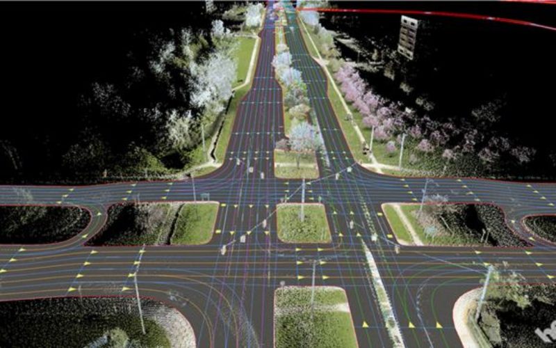
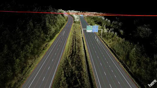
Ready to be deployed in connected vehicles in North America and Western Europe, HD Live Map creates a highly detailed and dynamic representation of the road environment, enabling a vehicle to effectively “see around corners” beyond the reach of its on-board sensors. HD Live Map is an integrated offering, consisting of multiple layers of data delivered in a map tile format.
Advantages of HERE HD Live Map
- It is designed to enhance both Advanced Driver Assistance Systems (ADAS) and automated driving functionality,
- Make driving more comfortable and enjoyable,
- HD Live Map includes data which tends to have high permanency, such as lane level information; data which is temporal in nature, such as road construction, traffic and accidents; and analytics data, including speed profile information that informs the vehicle about how to drive based on actual human behavior data.
- With HERE HD Live Map, automakers have the ability to enhance a vehicle’s ADAS functionality – such as adaptive cruise control, adaptive headlights and curve speed warnings – by giving it access to more accurate and more reliable near real-time content and contextual information about its environment.
- HD Live Map is also data-efficient, requiring a small data footprint, with new events able to be layered on the map without the need to update the whole map itself.
- In the near-term, HD Live Map utilizes a variety of data gathered and delivered by the HERE location platform to enhance the vehicle and the driver’s awareness of what’s happening on the road
Map-based ADAS
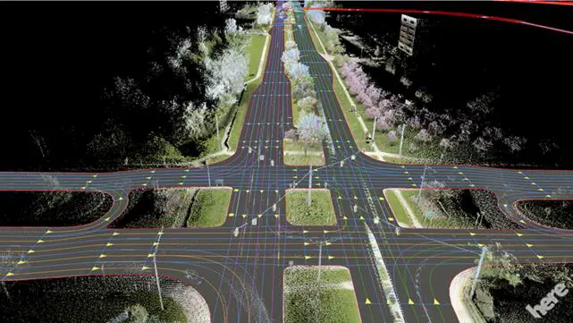
First ever self-maintaining map HERE HD Live Map is the first ever map from HERE which is self-maintaining: through multiple modes of sensor aggregation and ingestion the vehicle’s map is updated and delivered in near real-time.
For example, if vehicle sensors detected a speed limit sign which is inconsistent with what is currently in the map, the map would update accordingly so that other vehicles driving approaching the same spot have the new, correct information. This is important for ADAS functionality such as adaptive cruise control. Similarly, if a new lane closure was reported, the map would update accordingly so that other vehicles approaching the area can already prepare to switch lanes or alternatively re-route if traffic is heavy.
https://youtube.com/watch?v=2hJlLlh0lck%3Fenablejsapi%3D1%26modestbranding%3D1%26fs%3D0%26rel%3D0%26wmode%3Dwindow
Now, with HD Live Map offered across key regions, HERE is able to support automakers seeking to widen and deepen their automated driving development efforts. In supporting larger testbeds, HERE intends to continue to refine HD Live Map together with automakers to ensure it is optimized for their needs today and tomorrow.
Commenting on the launch of HD Live Map, analysts at IHS Automotive said: “Highly-detailed map data is not only very useful but a requirement for full-featured automated and autonomous driving. In the near term, highly-detailed map data will enhance the performance and benefits of current-generation driver assist technologies; over the longer term, they will enable more effective and efficient operation of vehicles altogether by drivers or self-driving cars. Adding a feedback loop to continually gather, update and share the latest road data will further elevate the technology’s potential.”
To know more about why autonomous cars can only understand the real world through a map, please read our HERE 360 blog.
Source: HERE