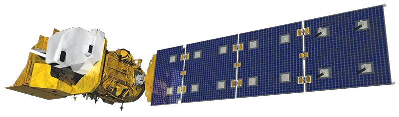
Landsat 9 Satellite – Latest and Powerful Satellite in the Landsat Series
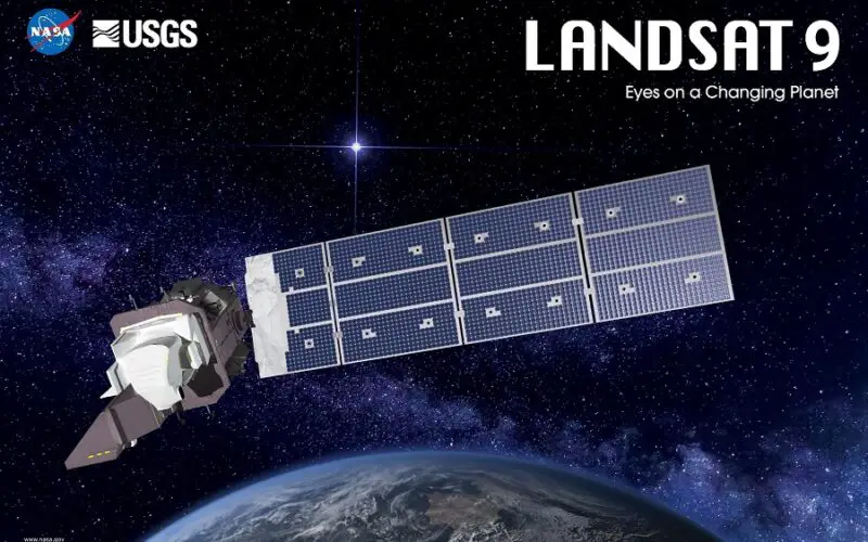
NASA has successfully launched Landsat 9 from Vandenberg Space Force Base using Atlas V rocket on September 27, 2021. The Landsat 9 satellite will be the most powerful satellite in the Landsat series of satellites.
Landsat 9 satellite will be able to image the entire Earth every 16 days, and when combined with Landsat 8 entire planet can be scanned in 8 days. In other words, together Landsat 9 and Landsat 8 will provide a temporal resolution of 8 days. This is achieved because Landsat 9 will be placed in an orbit that is 8 days out of phase with Landsat 8 to increase temporal coverage of observations.
Landsat 9 is designed to last at least 5 years in orbit and replace the aging Landsat 7. To reduce the build time and a risk of a gap in observations, Landsat 9 largely replicates its predecessor Landsat 8.
Landsat 9 Sensors
Landsat 9 carries two science instruments – the Operational Land Imager 2, and Thermal Infrared Sensor 2.
Both the instruments have sensors with moderate spatial resolution—15 m, 30 m, and 100 m depending on spectral bands – and the ability to detect a higher range in intensity. Landsat 9 has a radiometric resolution of 14-bit which is higher than Landsat 8’s 12-bit radiometric resolution.
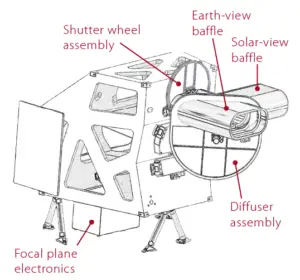
Operational Land Imager-2 (OLI-2)
The Operational Land Imager-2 (OLI-2) is largely identical to Landsat 8 OLI, providing calibrated imagery covering in the visible, near-infrared, and shortwave infrared light.
The OLI-2 is a push-broom sensor. So its focal plane has a long array of photosensitive detectors Incident radiation is focused onto the focal plane by a four-mirror anastigmatic telescope. OLI-2 has a 15-degree field-of-view covering a 185 km across-track ground swath.
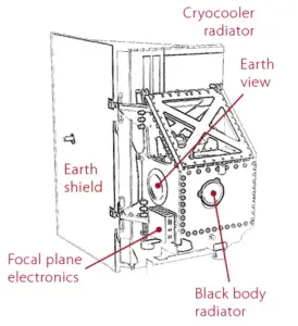
Thermal Infrared Sensor-2 (TIRS-2)
The Thermal Infrared Sensor-2 (TIRS-2) will measure the thermal infrared radiation, or heat (brightness temperature), of Earth’s surfaces. TIRS-2 improves upon Landsat 8 TIRS, addressing known issues including stray light incursion and a malfunction of the instrument scene select mirror. In addition, Landsat 9 adds redundancy to TIRS-2, thus upgrading the instrument to a 5-year design life commensurate with other elements of the mission.
Landsat 9 satellite will maintain the current data acquisition rate of up to 740 scenes per day, with these scenes available from the Landsat archive at no cost to users.
Landsat 9 Bands
Landsat 9, like Landsat 8, is designed to simultaneously image in –
- 4 visible spectral bands – 30 m spatial resolution,
- 1 near-infrared spectral band – 30 m spatial resolution,
- 3 shortwave-infrared spectral bands – 30 m spatial resolution,
- 1 panchromatic band – 15 m spatial resolution,
- 2 thermal bands – 100 m spatial resolution.
Landsats 8 and 9 are designed to see two additional parts of the spectrum. These new bands (not available in Landsat 7 and earlier Landsat series satellites) help scientists measure high, thin clouds and water quality. These bands are –
- Coastal/Aerosol Band (Band 1) – This band helps scientists measure chlorophyll concentrations (ocean color) in coastal regions. This band is also useful for aerosol detection.
- Cirrus Band (Band 9) – High, thin cirrus clouds can be hard to spot in satellite images. Landsats 8 and 9 are designed to detect these clouds by measuring light in the part of the electromagnetic spectrum where the clouds are most visible.
- Two Thermal Infrared Bands (Bands 10 & 11) – Everything on Earth emits thermal infrared radiation. The amount of emitted radiation depends on the object’s temperature. Landsat 9, like Landsat 8, will image data for two distinct thermal infrared spectral regions. The stray light issues that have plagued Landsat 8 will be corrected on Landsat 9.
Quick Facts
- Science Instruments: OLI-2; TIRS-2
- OLI-2 build: Ball Aerospace & Technology Corp.
- TIRS-2 build: NASA Goddard Space Flight Center
- Design Life: 5 years
- Spacecraft Provider: Northrop Grumman
- Image Data: > 700 scenes per day
- Launch Date: Sept. 27, 2021
- Launch Vehicle: United Launch Alliance Atlas V 401
- Orbit: near-polar, sun-synchronous at an altitude of 438 miles (705 km)
- Orbital Inclination: 98.2˚
- Spacecraft Speed: 16,760 mi/hr (26,972 km/hr),
- Consumables: 10 years
Landsat 9 will keep enabling user community like its predecessor’s to –
- Monitor land use land cover changes and understand the environmental consequences
- Watch on deforestation, global forest dynamics, and to verify the claims of environmental protection and carbon storage,
- Managing and mapping water resources for effective usage,
- Coral reef degradation,
- Glacier and ice-shelf retreat,
- Monitor Natural and man-made disasters to save lives,
- Climate change.
Also Read
Using Landsat Vegetation Indices to Estimate Impervious Surface Fractions for European Cities
Source – NASA