Geospatial Technology Helps To Find Remains of Major New Prehistoric Stone Monument
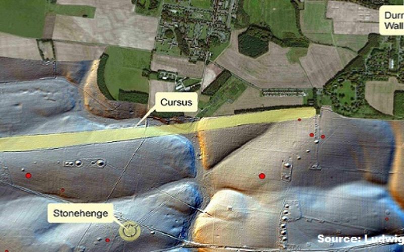
A team of researchers has found the remains of a major new prehistoric stone monument. They have been discovered less than 3 kilometres from Stonehenge. Using cutting edge, multi-sensor technologies the Stonehenge Hidden Landscapes Project has revealed evidence for a large stone monument hidden beneath the bank of the later Durrington Walls ‘super-henge’. This new discovery has significant implications for our understanding of Stonehenge and its landscape setting.
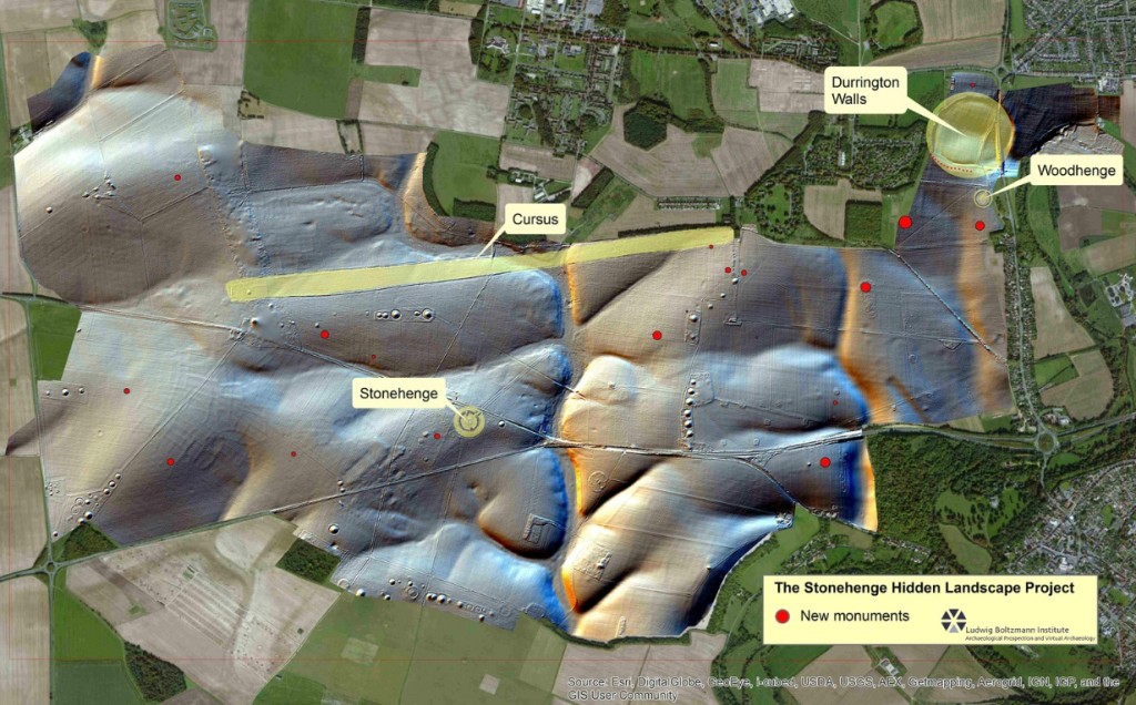
Mr. Wolfgang Neubauer, project initiator, archaeologist, archaeological prospection expert and director of the Ludwig Boltzmann Institute ArchPro in collaboration with M VISTA Laboratory – University of Birmingham has carried out Stonehenge Hidden Landscapes Project. The study using non-invasive geophysical prospection and remote sensing technologies, has now discovered evidence for a row of up to 90 standing stones, some of which may have originally measured up to 4.5 metres in height, Many of these stones have survived because they were pushed over and the massive bank of the later henge raised over the recumbent stones or the pits in which they stood. Hidden for millennia, only the use of cutting edge technologies has allowed archaeologists to reveal their presence without the need for excavation.

The primary purpose of the case study is the test and development of new, highly efficient prospection methods. Traditionally geophysical prospection methods have been used manually, permitting only slow measurement progress. Using multichannel motorized magnetometer and ground penetrating radar systems and exact satellite positioning systems is has become possible to map large areas quickly and with very high resolution. The study has proven to be huge breakthrough in the application of geospatial technologies in identifying and protecting archeological monuments.
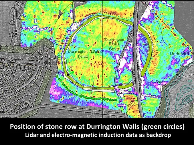
Previous, intensive study of the area around Stonehenge had led archaeologists to believe that only Stonehenge and a smaller henge at the end of the Stonehenge Avenue possessed significant stone structures. The latest surveys now provide evidence that Stonehenge’s largest neighbor, Durrington Walls, had an earlier phase which included a large row of standing stones probably of local origin and that the context of the preservation of these stones is exceptional and the configuration unique to British archaeology.
The team has used magnetometer measurements and ground penetrating radar surveys for large-scale high-resolution archaeological prospection.
Remote sensing methods, apart from aerial photography (both oblique- and ortho-photos) are airborne laser scanning and hyperspectral scanning promising method for the digital detection, mapping and documentation of buried archaeological sites and remaining traces in the topography.
Professor Neubauer, director of the LBI ArchPro said:
“Our high resolution ground penetrating radar data has revealed an amazing row of up to 90 standing stones a number of which have survived after being pushed over and a massive bank placed over the stones. In the east up to 30 stones, measuring up to size of 4.5 m x 1.5 x 1 m, have survived below the bank whereas elsewhere the stones are fragmentary or represented by massive foundation pits”.
Visit Stonehenge landscape map
Imagery for download can be found under