Maximum Value Composite Images (MVC’s): A solution for Cloudy Image to calculate NDVI

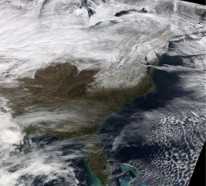 When the satellite views an area at any one time, a large part of the image may be cloud, which has a very low NDVI (approximately 0.002). This gives no information on the state of the vegetation beneath the cloud. This problem can be at least partially solved by using maximum value composite images (known as MVC’s). In this process the maximum value is found for each pixel over a time period such as ten days or one month. The maximum pixel value over such an interval is likely to be a cloud-free pixel. The time period is a trade-off: a longer period decreases the amount of cloud interference, but it means missing short-term variations. However, as vegetation does not change much on a time scale of days, the technique is useful. This process can be carried out using an image analysis packages, such as Image Display and Analysis (IDA) program. MVC’s have the added advantage of reducing the effects of other unwanted influences on the NDVI values (such as atmospheric interference).
Related Article:


