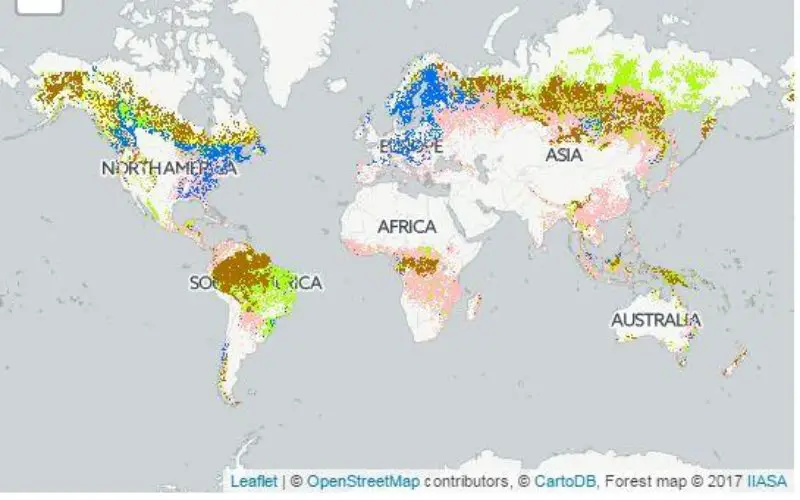
Using forest biomass products–such as timber, fuel wood, or paper–in a sustainable manner, without exhausting resources or diminishing forest biodiversity, requires transparency on the origin and management of those forests. One way to implement sustainable forest management is by certifying the area. By showing where certified forest areas are located and how they correlate with non-certified and primary forest land, a new global map released in June 2017 can provide a basis for a global pathway towards sustainable resource use.
To address the lack of openly accessible data on forest certification on a sub-national level, the global map shows certified forest areas at 1 kilometer resolution–far more detailed than currently available maps.
The map, which is available freely online and described in an article in the journal Forest Policy and Economics, was developed by researchers at the International Institute for Applied Systems Analysis (IIASA) together with the Mercator Research Institute on Global Commons and Climate Change (MCC) and the Norwegian University of Life Sciences (NMBU).

Certified Forest Map (IMAGE)
To view the interactive map please visit https://geo-wiki.org/branches/forest/.Photo Credit: Geo-Wiki/IIASA
The new map combines country-level statistics with modern remote sensing products and crowdsourcing. This high resolution approach–for the first time applied to forest certification and sustainability–allows a large range of users including policymakers, non-governmental organizations, researchers, forest organizations, private investors, and the general public to zoom into the area of their interest. It also provides a significant step forward in consumer transparency and credibility.
“This is the first tool where forest users and producers alike can find the spatial information they need on forest biomass sustainability. In order to identify environmentally sound biomass potentials—whether for local, regional, or global levels–it is of utmost importance to know if the biomass comes from sustainably managed origins. Our new map is the only tool that provides this information in reasonably high-resolution,” says IIASA Ecosystems Services and Management Program Deputy Director Florian Kraxner, who led the project.
To support data validation, the researchers used the interactive online crowdsourcing platform Geo-Wiki as a participatory and collaborative mapping tool where the different users can give feedback to improve the map. The new certification map is also openly accessible on the platform.
“We used country-scale data and developed a special logarithm to downscale it to a one-kilometer resolution. Then we brought this up to Geo-Wiki where everybody can help us to improve this data” said IIASA researcher Dmitry Schepaschenko, who designed the map on Geo-Wiki.
Before the release of this new high-resolution certification map there was very limited publicly accessible statistical data, which only allowed for aggregated assessment on national levels. However, the global map is fully consistent with recent certification data for example from the Forest Stewardship Council (FSC) and Programme for the Endorsement of Forest Certification (PEFC) at the country scale.
In addition, combining primary forest and protected area data in one map with information on certified and managed forests contributes to the insight into the possible impact of certification to combat illegal deforestation and halt forest degradation. This again supports effective policy making, for example in the coordination of environmental agreements–highly relevant in the face of rising biomass demand, which is putting pressure on forests around the world.
“We have to ensure that biomass converted into products such as energy does not further harm our climate mitigation efforts or biodiversity. The new map is a long-awaited tool that can serve as a sustainability and environmental safeguard,” says Sabine Fuss, a researcher at IIASA and MCC who also worked on the map development.
###
Reference
Kraxner F, Schepaschenko D, Fuss S, Lunnan A, Kindermann G, Aoki K, Dürauer M, Shvidenko A, et al. (2017). Mapping certified forests for sustainable management – A global tool for information improvement through participatory and collaborative mapping. Forest Policy and Economics 83: 10-18. DOI:10.1016/j.forpol.2017.04.014.
About IIASA:
The International Institute for Applied Systems Analysis (IIASA) is an international scientific institute that conducts research into the critical issues of global environmental, economic, technological, and social change that we face in the twenty-first century. Our findings provide valuable options to policymakers to shape the future of our changing world. IIASA is independent and funded by prestigious research funding agencies in Africa, the Americas, Asia, Europe, and Oceania. http://www.
Source: eurekalert.org