

Quantum technology-based Positioning, Navigation, and Timing (PNT) system as a backup for when GNSS satellites are not available is the need of the hour to overcome the limitations of satellite-based navigation. The system uses quantum sensors that are unaffected by interference or jamming. This is because they measure the orientation of the Earth’s magnetic field which cannot be tampered with by external forces.
Why Quantum Technology as Supplementary Navigation Solutions
The GNSS industry is seeing a shift toward the wide adoption of multi-frequency receivers across market segments to meet the diverging user needs of emerging applications, with four Global Navigation Satellite Systems (GNSS) available and more than 100 satellites in operation broadcasting multiple frequencies.
The entire Galileo system, including all of its satellites and base equipment, might be viewed as a single planet-sized clock. Because of the great precision of the atomic clock, meter-scale location can be achieved through ranging based on signal travel time.
Though GNSS is a great tool, however, it does have its limitations. One of them is that it is prone to natural or human-made interference. Another limitation is that it doesn’t work indoors. There are also many sites where these signals cannot be received, including as deep underground, under the sea, in woodlands, or in city centre ‘urban canyons.’
Autonomous vehicles, drones, and smart cities are all reliant on high-accuracy, reliable and resilient positioning, navigation, and timing (PNT) services. Currently, PNT is provided by the GNSS which suffers from interference, jamming, spoofing, and cyber-attacks. These attacks can come from rogue states or criminals aiming to take control of transport networks or bring down critical infrastructure.
Also, read – What Is Virtual Reference Station (VRS)?
As a response, researchers are searching for other positioning options to enhance or replace satnav as needed. Instead of planet-hugging satellite constellations, the ESA’s Navigation Innovation and Support Programme (NAVISP) incorporates research into the polar opposite of size — quantum technology.
NAVISP Programme – Quantum Technology as Supplementary Navigation Solutions
In the last few years, quantum technology has attracted a lot of attention in the scientific community. It is often claimed that this technology will revolutionise many sectors, such as computing, sensing and communications. The European Space Agency (ESA) is not behind in this race for developing new innovative technologies. ESA initiated the NAVISP programme to explore the potential of quantum technology for space applications.
The NAVISP programme is a public-private partnership between ESA, the European Commission and the satellite navigation industry. It aims to support activities that benefit European citizens and businesses by developing new applications and services based on Galileo and EGNOS. The Programme has identified a number of specific areas where the development of new technologies could improve current capabilities and provide for future needs.
The development of a quantum sensor could be used in conjunction with the current satellite navigation systems to give improved performance in certain areas. Quantum technology works better at lower temperatures, so you could use it in a hostile environment such as deep space. The current location and status of all the satellites in orbit are visible on the ground, but if you have something in deep space that is autonomous you need a clock onboard that can tell you the time because there’s no way of knowing the time on Earth from your position.
Cold-Atom Interferometry (CIA) – A Quantum Technology
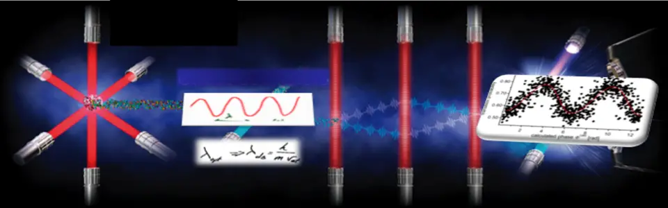
A highly innovative miniaturized quantum inertial measurement unit (QIMU) is based on Cold-Atom Interferometry (CIA) where atoms are cooled down to micro-kelvins and placed in an interferometer with optical pumps and beams. This device can then be used as a navigation sensor by measuring the rotation rate or acceleration of the spacecraft it is mounted on.
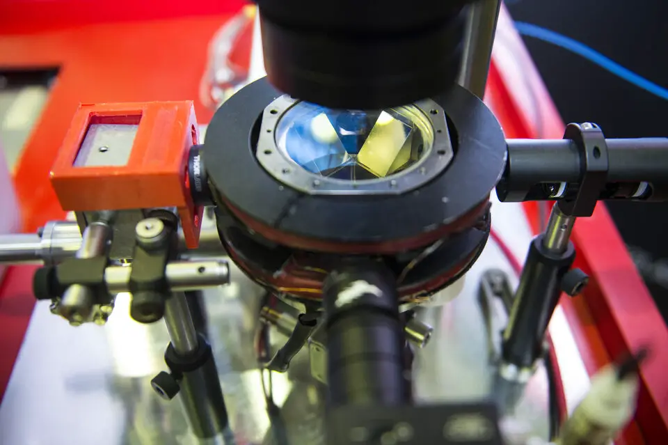
Cold Atom Interferometers (CAIs) are based around a few hundred thousand atoms at a time, trapped by a combination of lasers and magnetic fields. Atoms in ‘quantum superposition,’ which means they exist in many quantum states at the same time, are then interrogated by a laser to determine their interference patterns, which disclose things like gravity or other forces operating on them. CAIs and similar quantum technology can run with extremely high performance levels without the use of satellite navigation; the challenge is getting them to work reliably and robustly outside of lab contexts.
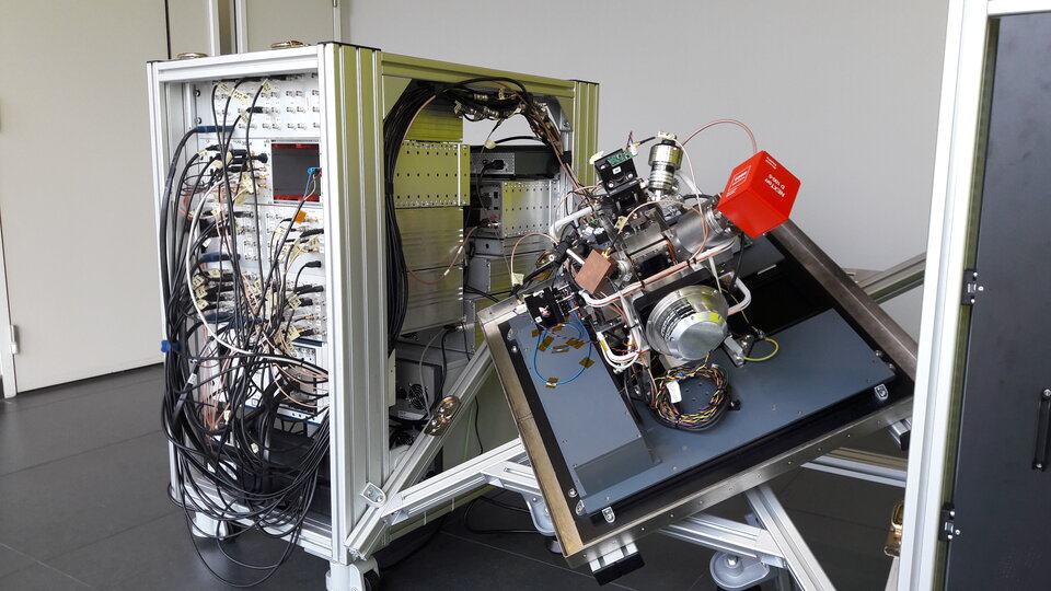
Inertial navigation company iXblue is leading a NAVISP project consortium to develop a compact 3-axis CAI sensor, aimed for use aboard boats, aircraft and boats as well as at fixed sites.
This could be used both on a dead reckoning basis – to accurately tote up all subsequent movements relative to its starting point, without the gradually accumulated drift of classical inertial sensors – and also to fix positions, such as by matching local gravity to a detailed gravity map.
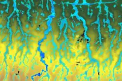
Meanwhile, the NAVISP Quantum Wayfarer project, which is being conducted by Teledyne in collaboration with the University of Liverpool, has explored the possibility of gravity map matching in practise.
Local gravity levels are controlled by various variables like as Earth’s rotation, surrounding topography, geology, and human-made structures, and have been mapped globally from orbit by several spacecraft, most recently by ESA’s GOCE (Gravity field and Ocean Circulation Explorer) mission.
The best baseline gravity maps would have a current accuracy of 90 metres, which might be improved to 30 metres in the near future, and could be integrated with additional reference sources like magnetic field mapping.
Conclusion
ESA’s NAVISP programme has the potential to use Quantum Sensors to significantly improve the performance of existing and future positioning, navigation and timing (PNT) systems. This will help Europe maintain its leadership in this field.
A more sensitive CAI gravimeter, on the other hand, would result in a higher frequency of gravity gradient measurements, leading to further improvements in map matching – potentially following the SLAM approach developed for robotics navigation, in which maps are created by a robot while its movement is tracked.
Also, read – What is SLAM Algorithm and Why SLAM Matters?
NAVISP is also evaluating other quantum technologies, such as quantum communications for authentication and time and frequency transfer, optical atomic clocks that use light instead of radio-frequency emissions, and quantum computers.
Source – ESA


In the discussion of the NAVISP Quantum Wayfarer project the following statement was made: “…The best baseline gravity maps would have a current accuracy of 90 metres, which might be improved to 30 metres in the near future…”
What method was used to measure gravity at this (90m) resolution? Are these maps generally available to the public for research use? How might they be improved to a resolution of 30m in the near future?
The Terrestrial Gravity Data is available at – https://ggos.org/item/terrestrial-gravity-data/
Accuracy can be improved by combining with other reference sources such as magnetic field mapping, such as a more sensitive CAI gravimeter could produce a higher frequency of gravity gradient measurements.