
How UAV LiDAR Technology Is Transforming Operational Forest Management
This case study from Routescene demonstrates the value of UAV LiDAR-derived point cloud data for operational forest management. Traditionally gathering metrics and information for forest management has been undertaken using airborne photogrammetry or by manually walking the site. More recently airborne LiDAR has been recognized as a useful tool and now drone-derived LiDAR data is proving its significant worth to monitor and manage the health and value of a forest.
Point cloud data and the Digital Terrain Models (DTMs) created can be used to establish meaningful metrics such as tree height and growth rate. These measurements are critical to assess forest health, limit the spread of diseases, prepare carbon capture and biomass estimates, ascertain drainage patterns and fuel load estimates for forest fire prevention.
The UAV LiDAR Technology in forestry Survey
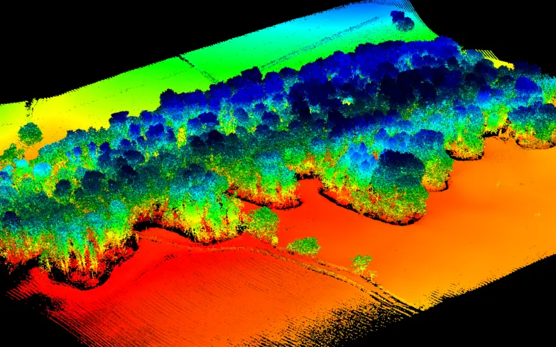
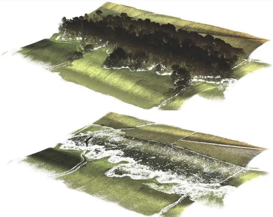
An area of woodland (10.9 acres / 4.4 hectares) was surveyed in Yorkshire, UK. The equipment used for this project was Routescene’s High Specification UAV LiDAR System, developed for survey-grade mapping where accuracy is critical. The Velodyne HDL-32 LiDAR sensor used in this system has a proven record of robustness, high accuracy, and high resolution. It can operate in dual return mode and provides a scan rate of up to 1.4 million points per second from 32 different lasers with a wide field of view. This means the system excels in the penetration of dense vegetation enabling both the ground and individual trees to be mapped to a high level of detail.
For this project, a critical metric to be determined was the “Diameter at Breast Height” (DBH) for each tree. This is challenging as it requires as high-resolution data as possible to be captured of the tree trunk. To achieve this the drone needs to be flown in tight flight lines and low and slow over the canopy. This demands careful survey and flight planning, factoring in extra flying time, and accurately determining the safety margin between the drone and the canopy to avoid any collisions with particularly tall trees.
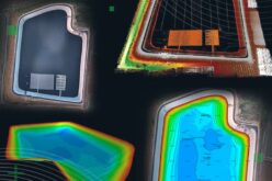
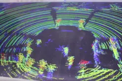
The drone was flown at an average height of 45m and a velocity of 5m/s. This enabled the UAV LiDAR system to collect a total of 8,912,679 points, used to create an incredibly dense 3D georeferenced point cloud. This high point density meant trees could be individually identified, with metrics and information extracted on an individual tree basis. This approach is particularly useful in variable heterogeneous forest environments such as this site.
Processing the Results
Processing for this project was undertaken using Routescene’s proprietary LidarViewer Pro software, designed specifically for large LiDAR survey datasets.
Identifying Individual Tree Crowns
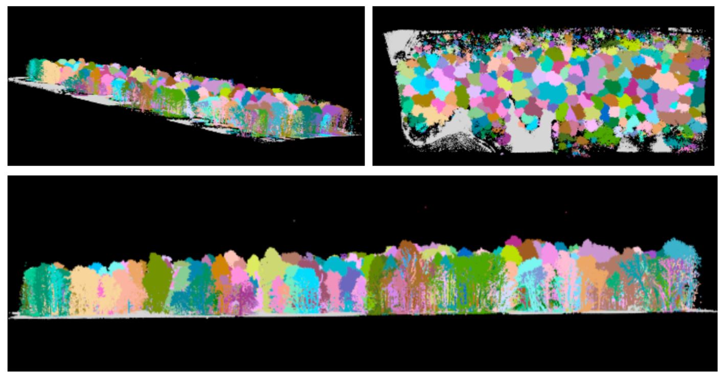
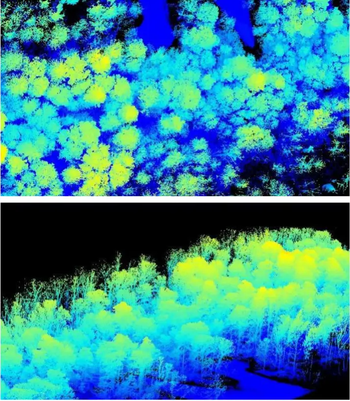
From the LiDAR point clouds, the identification of individual tree crowns can be achieved through many approaches. For highly detailed point clouds such as the Barnsley dataset, algorithms to identify individual trees can be applied directly to the LiDAR point cloud. This typically provides a more detailed segmentation as the methodology uses information from the point cloud to locate and identify individual trees. Following segmentation structural metrics can be derived using all points associated with the tree. The individual tree identification using the entire point cloud for the Barnsley dataset identified a total of 321 trees.
Also, Read – Remote Sensing and GIS for Sustainable Forest Management
Creating a DTM to Assess Ground Characteristics
A Bare Earth Model or DTM was created in LidarViewer Pro by using a series of filters to extract the model. The Bare Earth Model is in the first instance created within the computer’s memory using a grid of cells containing statistical information (min, max, mean, standard deviation). The minimum height values are used to seed the model and then these points are moved downwards based on the topology of adjacent cells. This iterative process results in a Bare Earth Model which removes features such as buildings and trees, whilst retaining the natural topography.
The resultant model is then used as a filter in its own right, with the whole point cloud being passed through the model, and any point that is within a certain distance of the model will be retained, whilst the rest of the points are discarded. This method allows for a very high-resolution ground model to be created.
DTMs generated from points classified as ground returns can be a useful dataset for forest management. In particular, information about ground characteristics such as slope can inform the planning and execution of timber harvesting, by establishing where the ground could be waterlogged to best locate skid trails and prevent excessive damage by forestry equipment; and to inform drainage planning.
Standard Height Metrics
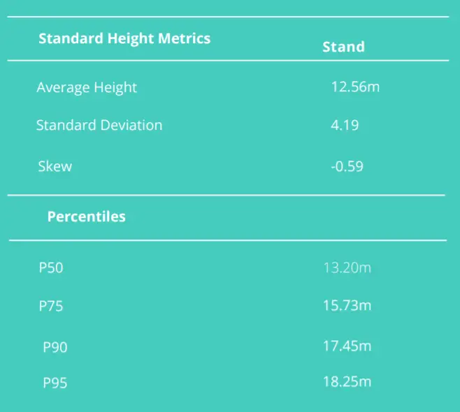
Standard metrics summarizing height can provide a basic overview of the forest structure. This can be calculated for the forest stand or calculated for each individual tree. A forest stand is a contiguous community of trees sufficiently uniform in composition, structure, age, size, class, distribution, quality, or location to distinguish it from adjacent communities. Due to the strong relationship between canopy height and other biophysical parameters, this data can be used to estimate information such as stand volume, biomass, basal area, and mean stem diameter.
Also, Read – Automated Point Cloud Analysis for Forestry Mapping
Applications in Forest Management
The above metrics and other structural information that can be derived from point clouds can be useful for a variety of forest management tasks.
Forest Fire Mitigation
Canopy bulk density (CBD) and canopy base height (CBH) are important parameters for canopy fuel estimation in fire modeling. CBD is used to predict crown fire spread. CBH is the average height from the ground to the underside of the canopy.
Identifying Disease
Bicentile metrics which represent the percentage of LiDAR returns recorded at different tree height percentiles have been used alongside canopy cover and canopy density metrics for the detection of canopy defoliation associated with the disease.
Carbon Sequestration
LiDAR metrics have been used to derive information pertinent to carbon sequestration which enables the amount of carbon dioxide that is stored in the forest to be quantified. The Woodland Carbon Code (WCC) (www.woodlandcarboncode.org.uk) is the quality assurance standard for woodland creation projects in the UK and generates independently verified carbon units. The WCC has created a carbon assessment protocol that details how the biomass of existing woodland is to be determined. Some of the steps to undertake the carbon assessment include: deriving a tree stem volume estimate for each species; estimating, for each stand of trees, the allocation of biomass in different parts of the tree; and then finally converting the biomass estimates to their carbon equivalents.
Measuring Forest Changes Over Time
Investment in forestry is a long-term strategy both for environmental and commercial purposes. The repeated assessment of a forest over time will highlight structural changes for example defoliation, which can be associated with disease and can be used to identify and limit outbreaks of pests and infection. Such monitoring over time also informs growth rates, carbon sequestration, the windthrow, deforestation, and post-harvesting residue quantification.
Conclusion
The resulting survey produced DTMs that will inform future conservation and land management. High-resolution LiDAR point clouds provided 3D data for the detailed assessment of forest structure at the individual tree level. This information can be useful for tree mapping, timber volume, biomass volume, and pre-harvesting assessments. Repeating the survey will inform structural changes through the seasons and over time. LiDAR technology can also be fused with other remotely sensed information such as hyperspectral or thermal imagery which could provide an even more accurate picture of the health of the forest and assist with the classification of tree species. As LiDAR and other remotely sensed technology continue to develop, more information can be acquired to help prevent forest decay and inform conservation.
The information collected can be utilized for a number of different scales to provide information to support forest management activities. For example, even though small proportions of a complete forest may be scanned using a UAV LiDAR technology system, describing the characteristics of these parcels can provide sufficient representative information for the majority. The results can be used to develop management objectives, for instance, growth monitoring and harvesting planning.
About Routescene®
At Routescene® we’re always looking beyond the point to help solve real problems. We design, develop and manufacture integrated 3D LiDAR mapping solutions specifically for use on drones. Designed by surveyors, our survey-grade end-to-end systems solve specific industry problems, save time, improve efficiencies and increase productivity. We’ve made it simple for you.
Colorado, USA and Edinburgh, UK
email: sales@routescene.com; www.routescene.com
*This article was originally published in GIS Resources magazine, December 2021 issue. The magazine can be read here.