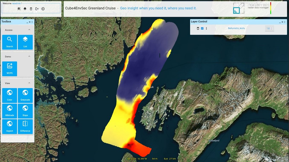
New QGIS Plugin Brings WCPS-Powered Datacube Querying to Open-Source GIS

The Open-Source GIS community welcomes a powerful new addition: the QGIS WCPS Plugin, enabling seamless querying and visualization of multidimensional datacubes.
This innovative plugin integrates the OGC Web Coverage Processing Service (WCPS) standard, allowing users to perform complex spatial and temporal analytics without the need for extensive coding. With WCPS, users can efficiently query large-scale raster datasets and visualize results directly in QGIS.
Key Features:
- Datacube Analytics Made Easy – Execute WCPS queries effortlessly within QGIS.
- OGC Standards-Based – Leverages the Web Coverage Processing Service (WCPS) standard for geospatial analysis.
- No Coding Required – Perform advanced spatial and temporal analytics without programming expertise.
- Seamless Visualization –
View and interact with query results instantly in QGIS.
Users can get started with the WCPS tutorial or the comprehensive cheat sheet while the plugin download is available here.
For more details, visit the plugin home page.
This plugin marks a significant step forward in expanding QGIS’s capabilities for large-scale geospatial data analysis, empowering researchers, analysts, and GIS professionals worldwide.
For any questions, please contact:
Peter Baumann, baumann@rasdaman.com
About QGIS
QGIS is a leading open-source Geographic Information System (GIS) application used globally for spatial data visualization, analysis, and mapping.