The first satellite of Taiwan’s home-grown earth-observation constellation, FORMOSAT-8, successfully blasted off on 28 November 2025 from the Vandenberg Space Force Base in California. Named “Chi Po-lin Satellite,” after the late documentary photographer, the satellite — code-named FS-8A — marks a major leap in Taiwan’s remote sensing capabilities.
What Makes FORMOSAT-8 Special
FORMOSAT-8 is not just a single satellite. It is planned as a constellation of eight optical remote-sensing satellites orbiting in a sun-synchronous orbit at about 561 km altitude.
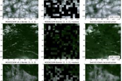
The aim is to deliver high-resolution imagery at far better clarity than older satellites. The first satellite captures images at a native ground resolution of 1 metre — and after processing, resolution sharpens to about 0.7 metres.
As the constellation grows, some satellites are designed to go even beyond that — delivering resolution down to around 0.5 metres.
That leap in imaging quality means the system can distinguish finer details — for instance, vehicles on a highway, differentiate between a truck and a car, or monitor subtle changes on the earth’s surface.
Also Read – SpaceX Falcon 9 Successfully Launched Taiwan’s Formosat-5
Why this Matters
Better, more frequent imagery has wide-ranging applications. For a disaster-prone region, it means quicker and more accurate damage assessment after earthquakes, typhoons, or floods. Authorities can respond faster, plan recovery efforts more precisely, and use data-driven strategies to allocate resources.
The constellation’s improved revisit rate — the frequency with which the same location is revisited — is a big plus. Where the older satellite FORMOSAT-5 passed roughly once every two days, the full FORMOSAT-8 constellation is expected to image Taiwan up to three times a day.
That makes high-resolution imagery not just sharp, but timely — increasing the chances of getting usable data even when weather (like cloud cover) interferes.
What’s Next — The Road Ahead
The fully operational FORMOSAT-8 constellation (all eight satellites) is planned to be completed by 2031.
Beyond disaster management, the program promises to support national security, environmental monitoring, land-use planning and even contribute to international cooperation on Earth observation data sharing.
With this launch, Taiwan’s space agency has effectively embraced a new era of satellite-based surveillance and mapping. The greater clarity and timely data from high-resolution imagery could prove instrumental in shaping response strategies, environmental policy, and security planning.
Conclusion
The successful launch of FORMOSAT-8’s first satellite marks a milestone in Taiwan’s space and Earth-observation efforts. With ground resolution down to 0.7 metres (and ultimately 0.5 metres), FORMOSAT-8 ushers in a powerful era of high-resolution imagery, strengthening capabilities in disaster response, national security, and environmental monitoring. As the remaining satellites join the constellation by 2031, the program promises to bring even sharper eyes to Earth.
Source: Taipie Times, RTI News, Taiwan Today