
Tag "Satellite imagery"

SI Imaging Services and GHGSat will gain a foothold for carbon neutrality with satellite imagery
SI Imaging Services (SIIS), a firm providing high-resolution satellite imagery, will operate a joint booth with GHGSat, a methane tracking satellite firm in Canada, at the World Gas Congress 2022
SIIS and UP42 Agreement Makes KOMPSAT Satellite Imagery Available on the Marketplace
SI Imaging Services (SIIS) of Daejeon, South Korea and UP42, have signed an agreement to make imagery from the KOMPSAT satellites available on the UP42 marketplace and developer platform. The
Aspectum and Planet Enter into a Partnership to Offer Powerful Analytics Paired With Robust Satellite Imagery
New partnership that allows Aspectum users to access Planets high-resolution satellite imagery and rich geospatial data Aspectum and Planet have announced the formation of a strategic partnership to offer businesses

How Google is Using Satellite Imagery for Mapping Wildfires?
Google Earth Engine is at the core of processing satellite imagery for mapping wildfire. The satellite images then processed using Google Earth Engine processing libraries for data analysis.
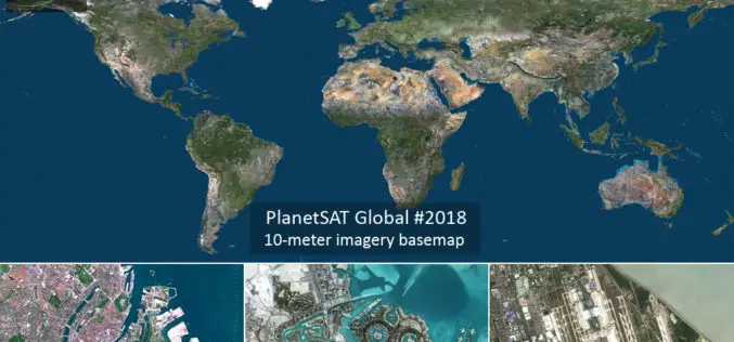
PlanetObserver Announces Release of PlanetSAT Global Imagery Basemap Version #2018
Clermont-Ferrand, France – 27 March 2018 – PlanetObserver, provider of geospatial data for civil and military solutions, announces the release of the most up-to-date global mosaic processed with recent and

Microsoft India Using Artificial Intelligence to Help Indian Farmers
New Delhi: New technologies such as Artificial Intelligence (AI), Cloud Machine Learning, Satellite Imagery and advanced analytics are empowering small-holder farmers in India to increase their income through higher crop

DigitalGlobe Goes All-In on AWS
Global leader in commercial high-resolution satellite imagery selects AWS to support future growth and bring an advanced machine learning framework to geospatial data analysis SEATTLE–(BUSINESS WIRE)–Nov. 30, 2017– Today, Amazon Web

DigitalGlobe Delivers WorldView-4 High-Resolution Satellite Imagery to Power PSMA Australia’s Continent-scale Mapping Initiative
WorldView-4 Imagery To Become Available To All Commercial Customers On August 31 WESTMINSTER, Colo.–(BUSINESS WIRE)–Aug. 29, 2017– DigitalGlobe, Inc. (NYSE: DGI), the global leader in Earth imagery and information about our changing planet,
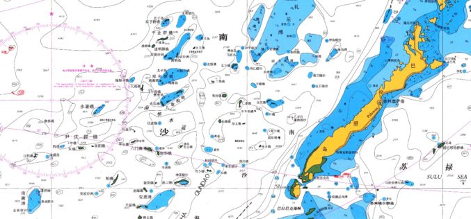
East View Expands South China Sea Imaging Capabilities
MINNEAPOLIS, Minn. – January 31, 2017 – East View Geospatial is enthusiastic to announce the expansion of analytic services in the South China Sea for foundation data and satellite imagery.

Indian Economic Survey 2017 Indicated ULBs Can Use Satellite Imagery for Property Mapping
According to recently report by the MonetControl Bureau – The Economic Survey 2017 indicated that the urban local bodies could use satellite imagery to map properties and generate additional revenue
