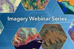
Get More From Imagery Webinar Rollout
Live Webinar – Thursday, April 9 at 8am GMT and 2pm EDT
 PCI
PCI
Register Now
About PCI Geomatics
PCI Geomatics is the developer of Geomatica®- a complete and integrated desktop software that features tools for remote sensing, digital photogrammetry, geospatial analysis, map production, mosaicking and more. Geomatica® software enables users to apply imagery in support of a wide range of applications such as the environment, agriculture, security and intelligence, defense, as well as in the oil and gas industries.
Categories:
Webinars