
Tag "satellite"
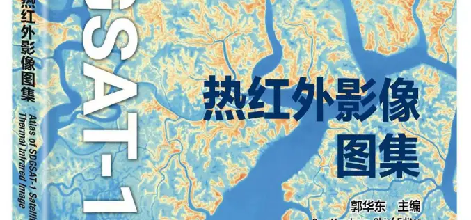
China Unveiled World’s First Thermal Infrared Atlas
China has made a groundbreaking contribution to global sustainability efforts by releasing the world’s first Thermal Infrared Atlas. The atlas was launched during the 4th International Forum on Big Data
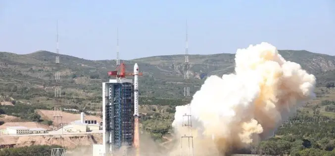
China Launches Hyperspectral Remote Sensing Satellite – Gaofen-5 02
China successfully launched the Gaofen-5 02 into space from the Taiyuan Satellite Launch Center in northern Shanxi Province on September 07, 2021. The satellite was launched using the Long March-4C

ISRO Successfully Launches Cartosat-3 and 13 Commercial Nanosatellites
November 27, 2019 – ISRO – India’s Polar Satellite Launch Vehicle, in its forty-ninth flight (PSLV-C47), successfully launched Cartosat-3 along with 13 Nanosatellites of USA from Satish Dhawan Space Centre

Russia, China Agreed to Hold Experiments to Increase Satellite Data Accuracy
Moscow, July 5. /TASS/. Russia’s State Space Corporation Roscosmos and the China National Space Administration (CNSA) have agreed to hold an experiment before October 1 to use testing grounds for

China Launches Two Satellites for Pakistan
Beijing, Jul 9, 2018 (PTI) – China has successfully launched two remote sensing satellites for Pakistan, marking the first international commercial launch for the Long March-2C rocket in about 19 years.
Esri Announces Release of Sentinel-2 Image Services
Redlands, California, May 29, 2018—Esri, the global leader in spatial analytics, today announced that it is releasing Sentinel-2 Image Services to all Esri users for no additional cost. Sentinel-2 is

Belarus, Russia, Kazakhstan to Make Space Satellites Together
MOSCOW, 25 May (BelTA) – Belarus, Russia, and Kazakhstan have come to terms on manufacturing cooperation for making satellites for the remote sensing of Earth. The decision was made at

TCarta Delivers Satellite Derived Bathymetry Data to Total for Hydrocarbon Exploration Project
BRISTOL, United Kingdom, 16 May 2018 – TCarta, a global provider of marine geospatial products, has delivered satellite derived bathymetry (SDB) to Total SA, one of the world’s largest oil and gas producers.

JAXA Successfully Deployed First Kenyan Satellite
Successful Deployment of First Kenyan Satellite, selected as First KiboCUBE programme of UNOOSA and JAXA JAXA, UNOOSA – On May 11, 2018, the first CubeSat developed under the KiboCUBE programme has been successfully

TCarta Delivers Satellite-Derived Land/Sea Floor Surface Models for Caribbean Disaster Recovery
BRISTOL, United Kingdom, 17 April 2018 – TCarta, a global provider of marine geospatial products, has delivered pre- and post-disaster surface models for the Caribbean islands of Antigua and Barbuda
