Pix4D Launches in the USA and Canada, the viDoc RTK rover, an iPhone Case that Enables Handheld Professional 3D Scanning
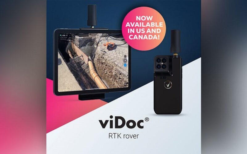
Pix4D, the market leader in photogrammetry solutions, has just made the viDoc RTK rover available for purchase in the USA and Canada. Already available in Europe, the German-designed rover attaches to the latest iOS devices to bring RTK accuracy to terrestrial scanning on iPhones and iPads.
The viDoc rover and PIX4Dcatch solution can replace the need for cumbersome and expensive survey tools such as RTK GNSS rovers and terrestrial scanners for a fraction of the price.
“The viDoc RTK is a very easy-to-use handheld device used to 3D model just about any small area or structure. Combined with processing in PIX4Dmatic with both LiDAR and photogrammetry data, it’s an exciting new and accurate product.” – Mark Paulson of VerticalAspect, a professional surveyor with 30 years experience and 10 years of experience working with drones and photogrammetry in surveying.
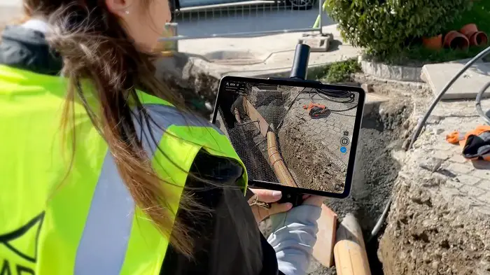
When paired with the PIX4Dcatch mobile app, the two products create a workflow that turns iPhones or iPads into an accurate terrestrial scanning device, with centimeter-accurate RTK positioning from your existing NTRIP network. PIX4Dcatch also takes advantage of LiDAR scanners in the latest devices, which are also leveraged during data capture and processing to improve scale and completeness. The result is a survey-grade tool in the pockets of professionals, replacing heavy LiDAR scanners and rovers.
The viDoc RTK rover for PIX4Dcatch is designed to be seamlessly integrated with all of Pix4D’s photogrammetry solutions. The easy workflow means users can go from scanning a site in minutes with the viDoc rover and PIX4Dcatch to processing on the cloud with PIX4Dcloud for 3D-models and volume measurements. Alternatively, they could process the data from PIX4Dcatch in the desktop software PIX4Dmatic and use both LiDAR and photogrammetry data to get the desired outputs, which can be added to PIX4Dsurvey for vectorization and be made ready for CAD.
The ease of use, affordability, and quality of the outputs of the viDoc RTK rover have the ability to disrupt the AEC industry and bring new workflows to fields including public works, accident reconstruction, and stockpile management.
The viDoc RTK rover is available for sale from Pix4D or licensed resellers across the United States and Canada.
About Pix4D
Pix4D (pix4d.com) develops cutting-edge software that converts images taken by hand, drone, or plane into accurate and georeferenced survey-grade 2D mosaics, 3D models, and point clouds. Founded in 2011, Pix4D is rapidly expanding from its headquarters in Lausanne, Switzerland, to offices in Berlin, Madrid, Denver, Shanghai, and Tokyo.
Pix4D is best known for PIX4Dmapper, the industry-leading photogrammetry software for drone mapping, and other software solutions like PIX4Dfields for agriculture, PIX4Dreact for emergency response, PIX4Dcloud for online drone mapping, progress tracking, and site documentation, PIX4Dinspect for automated industrial inspection and asset management, PIX4Dmatic for large scale or terrestrial mapping and PIX4Dsurvey for efficient terrain modeling and vectorization.
Pix4D is the exclusive distributor of the viDoc RTK Rover worldwide.
About the Manufacturer
The viDoc RTK was conceived by vigram GmbH, a German company led by professional surveyors.