Revolutionising Remote Sensing with Geospatial Foundation Models on AWS
The advent of geospatial foundation models (GeoFMs) is reshaping how we interpret and act on Earth-observation data. On Amazon Web Services (AWS), GeoFMs are transformer-based vision models that are pre-trained on massive satellite and remote-sensing datasets and ready for deployment across ecosystem and surface-level monitoring tasks. This article explores how GeoFMs on AWS differ from traditional geospatial solutions, their capabilities in detecting and monitoring conditions like forest degradation, crop yield, and natural disasters, and the diverse applications and advantages they bring.
What are GeoFMs, and how do they differ from traditional geospatial models
Traditional geospatial analysis and modelling often rely on:
- Hand-crafted features (for example, indices like NDVI or NDWI), tailored to specific tasks.
- Models trained from scratch for each domain (e.g., one model for forest loss, another for urban expansion).
- Large labelled datasets for each new task, along with significant feature-engineering and domain-specific tuning.
In contrast, GeoFMs on AWS bring a different paradigm:
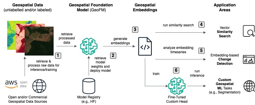
- They are pre-trained vision transformers (ViTs) specifically adapted for geospatial data: multiple spectral bands, spatio-temporal patterns, and variable input sizes.
- They serve as embedding models out of the box: you feed in satellite image chips and get back embedding vectors that encode rich semantic and spatial information.
- They support similarity search, change detection, and fine-tuning for custom downstream tasks with far less labelled data than conventional models.
- Because they are pre-trained on global data, they generalise better across ecosystems, reducing the effort for each new application.
The key difference is this: whereas traditional geospatial models are task-specific and heavy on labelled data, GeoFMs are foundational, flexible, and more efficient—especially when deployed on cloud services like AWS.
Also Read – Earth on AWS: Large Geospatial Datasets Available on the Amazon Web Services
How GeoFMs help detect and monitor surface-level ecosystem conditions
GeoFMs on AWS have strong utility in monitoring surface-level ecosystem conditions. Some illustrative use-cases:
- Forest degradation: By generating embeddings for satellite image chips over forested regions (e.g., the Amazon), GeoFMs enable change detection via embedding distance over time. Sudden deviations indicate possible degradation or clearing.
- Natural disaster impact: After events like floods, hurricanes, or wildfires, embedding-based change detection can rapidly signal areas where ground conditions changed significantly, enabling timely assessment and response.
- Crop yield and agricultural monitoring: GeoFMs can be fine-tuned or used to embed imagery of agricultural fields—capturing patterns of crop growth, stress, or yield potential—without starting from scratch. The AWS blog highlights agriculture as a prominent application.
- Surface condition and land-use change: Urban sprawl, wetland conversion, and mining can all be picked up via embeddings that reflect semantic changes in surface types and land-cover.
In essence, by converting raw satellite imagery into high-dimensional embeddings, GeoFMs make it feasible to monitor changes in ecosystems, surface conditions, and land-use at continental or global scales with far less manual effort than before.
Applications and Advantages of GeoFMs on AWS
Applications
- Environmental conservation: Early warning of forest degradation, illegal logging, and habitat loss.
- Disaster response: Rapid detection of flood/drought/wildfire extents and infrastructure damage assessment.
- Agriculture: Monitoring crop health, predicting yield, and detecting anomalies or stress.
- Urban planning and infrastructure monitoring: Detecting expansion, impervious surface change, and heat-island formation.
- Supply-chain and resource management: Monitoring mining or extraction activities and tracking changes in land-use linked to commodity supply.
Advantages
- Reduced labelled-data requirement: Because the model is pre-trained, fine-tuning demands much less data than custom models.
- Scalability: AWS services like Amazon SageMaker support large-scale inference and batch embedding generation, enabling continental-scale monitoring.
- Flexibility: One foundation model supports multiple downstream tasks (classification, segmentation, regression) rather than building many separate models.
- Access to open geospatial data: Through the AWS Open Data Program, users have access to large satellite archives collocated with compute services, enabling GeoFMs to act on rich datasets.
- Faster time-to-insight: Traditional workflows involving feature-engineering and bespoke model training are replaced by embedding generation and similarity search or change-detection, accelerating analysis.
Conclusion
GeoFMs on AWS mark a significant shift in geospatial analytics. By combining pre-trained transformer-based vision models tuned for geospatial data with the scalability of cloud infrastructure and open-data access, they deliver powerful new capabilities to map and monitor surface and ecosystem conditions—from forests and crops to disaster-impacted zones and urban sprawl. For technology readers working in remote sensing, environmental monitoring, or precision agriculture, GeoFMs present a compelling new foundation.
Source: AWS