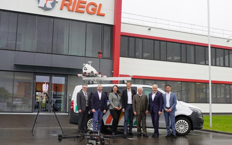
In 2021, RIEGL was awarded the contract for the delivery of three laser scanning systems for the Digital Twin Lab of JOANNEUM RESEARCH. Now, post-COVID, the both teams could finally meet in person at the RIEGL Laser Measurement Systems headquarters in Horn, Austria.
Upon delivery of a complete and fully integrated terrestrial, airborne, and mobile surveying system[1], RIEGL also invited the JOANNEUM RESEARCH team for a tour of the Manufacturing, Production, Research & Development headquarters.
Delivery and commissioning had been successfully carried out despite the COVID‑19 pandemic, but the campus visit in Horn had to be postponed indefinitely due to the Coronavirus regulations in force at that time in addition to internal company precautionary measures.
On May 17th, 2023, a delegation from JOANNEUM RESEARCH, led by CEO Dr Heinz Mayer, got a first-hand look at the complexity and vertical range of production at the RIEGL facilities. The delegation was also impressed by the innovative strength and the high-quality standard of the company in all areas.

Equipped with this innovative LiDAR technology, JOANNEUM RESEARCH’s Digital Twin Lab in Klagenfurt now provides companies in the region with easy access to the latest laser scanning technology and development services. The digital twins created from a basis of RIEGL LiDAR systems are used in the implementation of digital processes. Such processes include the planning, simulation, control and AI- supported information management of traffic routes, infrastructure, building complexes, agricultural areas, and industrial plants, etc.
Dr Matthias Rüther, Director of DIGITAL, Institute for Digital Technologies at JOANNEUM RESEARCH stated “Digitization of processes and cooperation at the location are key to a secure future: The development of digital spaces that are close to reality will be essential in order to remain fit for the future. And we will continue to establish expertise to support companies with innovations and strengthen their resilience. The Digital Twin Lab opens up completely new implementation possibilities. We are pleased that this is possible in collaboration with an established Austrian company.”
Managing Director and CTO at RIEGL, Dr Andreas Ullrich stated “We are proud that we, as an Austrian company, were able to equip the Digital Twin Lab project of JOANNEUM RESEARCH with our laser scanning systems. It is highly impressive for us to see the extent of innovative research and development in the field of digitization and the creation of ‘spatial digital twins’-based on RIEGL’s highly accuratesurvey data. The presented projects from the fields of autonomous driving, precise driving simulations and traffic monitoring in combination with AI technologies, for example, ensure JOANNEUM RESEARCH with the Digital Twin Lab an important pioneering role to advance research for the development of new transportation concepts and technologies. We wish the team around DI (FH) Patrick Luley much success in realizing the goals they have set!”
About RIEGL
With more than 40 years of experience in the research, development and production of laser rangefinders, distance meters, and LiDAR sensors and systems RIEGL delivers proven innovations in 3D.
The combination of RIEGL‘s state-of-the-art hardware for terrestrial, industrial, mobile, airborne, bathymetric and UAV-based laser scanning with appropriate, equally innovative RIEGL software packages for data acquisition and processing results in powerful solutions for multiple fields of application in surveying.
RIEGL has always been committed to delivering the highest performance, quality, reliability, and longevity of all its products and services, and strict adherence to applicable international standards is a priority.
About JOANNEUM RESEARCH Forschungsgesellschaft mbH
JOANNEUM RESEARCH, headquartered in Graz, is an innovation and technology provider in the field of applied research. As a research society of the states and regions, we shape the development of our modern society and economy with our research competencies in a sustainable and people-centered way. As a multidisciplinary team in flexible, innovation-friendly structures, we live the highest social and scientific standards.
[1] VZ-400i Terrestrial Laser Scanning System, VMX-2HA Mobile Mapping System, and RiCOPTER UAV Platform with integrated VUX-SYS Airborne Scanning System