
Tag "3D"
Create Photogrammetric Point Cloud Using Global Mapper Pixels-to-Points Tool
Global Mapper LiDAR Module v.19 Now Available with Pixels-to-Points™ Tool for Photogrammetric Point Cloud Creation November 29, 2017 – Blue Marble Geographics is pleased to announce the release of version 19 of the

Presagis Introduces New Automated Virtual Environment Production Solution
November 27 2017 – Montreal, Canada – Presagis™, a recognized leader in modeling and simulation software, today introduced VELOCITY, a next-generation software solution that automates the production of large synthetic training

Pix4D Partners with Kokusai Kogyo in Japan to Deliver a 3D Geospatial Analysis Cloud Service
Full automation for 3D spatial analysis that support i-Construction and public surveying November 20, 2017 – Pix4D is partnering with Kokusai Kogyo Corporation (KKC)—the leading geospatial consulting company in Japan–to deliver
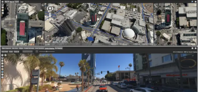
Orbit GT Releases 3D Mapping Feature Extraction Standard v18
Orbit GT launches the 3D Mapping Feature Extraction Standard product version 18. “We’re pleased to announce the release of our second product from the Feature Extraction portfolio”, says Peter Bonne,

IDS GeoRadar Unveils Ground Penetrating Radar to Improve Safety Before Cutting or Drilling into Concrete Structures
C-thrue is an all-in-one, robust solution to see through concrete structures and reveal true data October 24, 2017 – Pisa, Italy: IDS GeoRadar, a leading provider of multi-frequency, multi-channel Ground Penetrating

Kongsberg Geospatial Collaborating with Wind River for Safety-Critical Geospatial Applications
October 24, 2017 – Ottawa, CA: Kongsberg Geospatial, an Ottawa-based developer of geospatial software technology, announced today that they are collaborating with Wind River® to validate their safety-critical geospatial components for

4DMapper Incorporates Global Mapper SDK Enabling Cloud Based Geospatial Analytics
Hallowell, Maine – October 23, 2017 – Blue Marble Geographics (bluemarblegeo.com) is pleased to announce that 4DMapper (4dmapper.com), a geospatial technology company based in Australia, has chosen the Global Mapper Software
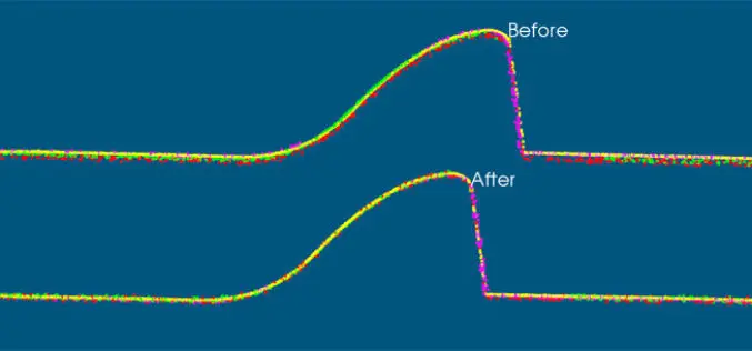
VRMesh V9.5 Available with New Advanced Features for LiDAR Strip Adjustment
Oct. 12th, 2017 – VirtualGrid is pleased to announce the availability of VRMesh v9.5, the latest version of its powerful 3D point cloud and mesh processing software. This new release

PDF3D Work With Forensics to Bring 3D PDF into the Court Room
3D PDF conversion software leaders, PDF3D, have today released a new eBook that will help forensic investigators and engineers improve presentation of evidence and 3D reconstructions in court. London, October

3D Modeling to Plan Development Projects in Jaipur City
Jaipur, India – According to recent news reported by the TOI, the Department of Information Technology and Communications (DIoTC) of Jaipur, has undertaken an ambitious ‘3D City Model’ project. The
