
Tag "ESRi"
Journal of Geography Article Earns National Council for Geographic Education Accolade
Esri Education Manager Tom Baker Co-Authors Best Article for Geography Program Development Redlands, California—A joint effort from Esri Education manager Tom Baker and a research group of seven university faculty

Singapore Housing & Development Board Leverages Geospatial Technology for Land Use Planning
Since land-use planning is vital in a land-scarce Singapore, the republic’s Housing & Development Board (HDB) has leveraged Geographic Information System (GIS) technology in its Integrated Planning and Analysis system
Esri Fosters Industry Innovation with Unique Startup Program
Initiative enables top startups to incorporate location analytics into their products and develop breakthrough solutions June 30, 2016-Redlands, California—Esri, the world’s leading mapping platform company,continues to foster industry innovation and

Trimble R2 GNSS Receiver Now Available for Data Collection
Collecting Professional Data Made Easier With Trimble R2 GNSS Receiver June 29, 2016 – Redlands, California—Esri announced today the availability of the Trimble R2 Global Navigation Satellite System (GNSS) receiver for

Singapore Land Authority 3D Smart Nation Map Debuts on the World Stage
The Singapore Land Authority (SLA) has revealed the highly anticipated first phase of its national 3D mapping project to an audience of more than 16,500 of the world’s leading geospatial

Australian Utility Sets Global Technology Benchmark
Queensland Urban Utilities (QUU) has won the renowned Esri Special Achievement in GIS (SAG) Award for Q-Hub, a technology system which provides a real-time location-based view of the utility’s entire

DigitalGlobe and Esri Announce New Long-Term Partnership to Expand World Imagery Map
WESTMINSTER, Colo.–(BUSINESS WIRE)–Jun. 27, 2016– DigitalGlobe, Inc. (NYSE: DGI), the global leader in earth imagery and information about our changing planet, today announced an agreement to make more current satellite
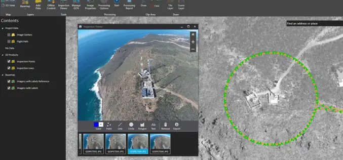
Esri Announces the Release of Drone2Map for ArcGIS
Drone2Map for ArcGIS is Now Available Esri is pleased to announce the release of Drone2Map for ArcGIS, our new desktop app that allows you to turn drone-captured still imagery into

SAP® Geographical Enablement Framework Simplifies Spatial Processing of Enterprise Business Data
SAP HANA® Accelerates Spatial Processing and Analytics for Real-Time Insights SAN DIEGO, Calif., June 28, 2016 /PRNewswire/ — SAP SE (NYSE: SAP) today unveiled SAP® Geographical Enablement Framework, powered by
Esri Launches National Green Infrastructure Initiative for Planning
Maps, Data Empower Local Communities to Identify, Protect, and Connect Nature’s Network Redlands, California—Esri, the world leader in geographic information system (GIS) technology, has launched a suite of public mapping
