
Tag "European Commission"
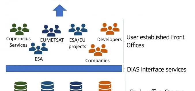
The Upcoming Copernicus Data and Information Access Services (DIAS)
The European Commission (EC) has launched an initiative to develop Copernicus Data and Information Access Services (DIAS) that facilitate access to Copernicus data and information from the Copernicus services. By

The Drone Leader DJI Will Exhibit in Europe for the First Time At The Most Important Drone Trade Show, ExpoDronica
Chinese drone manufacturer DJI, the world leader in sales, will exhibit at the second edition of Expodrónica Drone Trade Show in Zaragoza next 22nd and 23rd September. It will be

Sendai Framework for Disaster Risk Reduction
The Sendai Framework for Disaster Risk Reduction 2015-2030 provides a new global approach to disaster risk management policy and operations. In June 2016, the European Commission published an action plan
Copernicus Thematic Workshop With Private Sector Representatives on Raw Materials and the Extractive Industries
Copernicus Thematic Workshop With Private Sector Representatives on Raw Materials and the Extractive Industries Copernicus is a user-driven programme with an important impact on different societal areas involving diverse communities
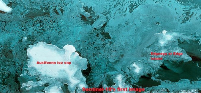
The First Images of Sentinel-1B
Launched on 25 April from Europe’s Spaceport in French Guiana, Sentinel-1B has produced its first images only two hours after the radar was switched on – a record time for
MYGEOSS – Third Call for Innovative Apps in The Environmental and Social Domains
MYGEOSS is launching an open call for the development of innovative applications (mobile or web-based) using openly available or crowd-generated data in different domains addressing citizens’ needs. The pool of

European Space Imaging Wins Additional Supply Contract for the European Commission
Munich, 16/12/15 – European Space Imaging announced today that the company has signed an additional multi-year framework supply contract with the European Commission for the provision of very high-resolution (VHR)
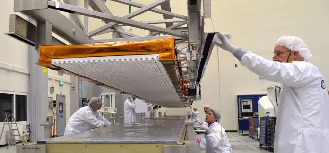
Airbus Defence and Space Delivers Sentinel-1B Radar with an Accuracy of a few Millimeters for Europe´s Copernicus Radar Satellite Mission
The Airbus Defence and Space built C-band radar instrument for the Copernicus Sentinel-1B satellite is now on its way to “meet” its spacecraft at Thales Alenia Space (TAS), Italy, the

Framework Contract for Supply of Satellite Remote Sensing Data, JRC, EC
Framework Contract for Supply of Satellite Remote Sensing Data, JRC, EC JRC/BRU/2012/H.6/0010/RC The purpose of this contract is to supply satellite data from the very latest sensors and products. The
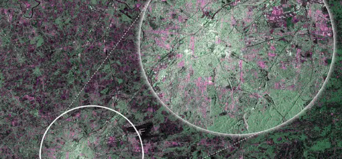
First RADAR Images of Earth by Sentinel-1A Satellite
ESA’s Sentinel-1A, kicked off on April 3, 2014, has delivered its first RADAR images of earth. ESA’s Sentinel-1A satellite will provide the ability of policymakers and service providers to access
