
Tag "geospatial"

Esri Releases EMUs to Understand the Ocean
GIS Enables a New Way to Measure Marine Environments Redlands, California—Esri, the world leader in smart mapping technology, announced a whole new way of measuring the ocean on September 15,

Drones to Monitor Indian Railways Projects
PTI- NEW DELHI: Stepping up the monitoring mechanism, railways has opted for the state of the art surveillance devices such as drone and geo-based spatial based satellite technology to monitor
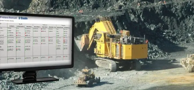
Trimble Connected Mine Provides Spatial Data Visualization Using Trimble and Microsoft Mixed-Reality Technologies
Trimble Provides a Single Source of Data Across the Mine Enterprise SUNNYVALE, Calif., Sept. 13, 2016—Trimble (NASDAQ:TRMB) announced today the release of its Trimble® Connected Mine™ Visual Intelligence module with

PDF3D Releases Microsoft OFFICE Enhancements with 3D Plugins
New plugins from PDF3D allow Microsoft Office users to enhance documents by adding interactive 3D images at the click of a button. London, UK, September 9th, 2016 – PDF3D, the

South Korea and Tunisia Sign MoC in the Field of Geospatial Data
As recently reported by ZAWYA (Thomson Reuters), South Korea and Tunisia has inked a memorandum of technical co-operation in the fields of geospatial data and land management in the event

ASTEC Launches Space-based Program for Empowering Panchayati Raj Institutions
Guwahati, India -According to recent news reported by The Assam Tribune, the Assam Science Technology and Environment Council (ASTEC) has launched outreach activities for space-based projects Empowering Panchayati Raj Institutions

NESAC Technology to Monitor Progress of 700 NEC Projects: India
Umiam (Meghalaya), Sep 5 (PTI) – Around 700 government projects funded by the North Eastern Council, which are facing delay and cost over-run in eight states of the north east
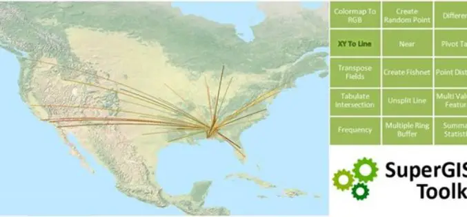
Accelerating Your Geospatial Work with SuperGIS Toolkit 10
Currently, spatial information is widely used in many industries, and the demand for analyzing and processing spatial data is also booming. To meet needs from different industries and users, Supergeo

India to Ink Agreements With US on Sharing Geospatial Information and Data
According to recent news published by The Indian Express, following the inking of an important logistical pact (LEMOA) with the US, Defence Minister Manohar Parrikar has indicated that India is
Kongsberg Geospatial and FAA ASSURE UAS Centre of Excellence Partner for Operational Trials of Detect and Avoid and Beyond Visual Line of Sight Display Software
Ottawa, CA, 29 August 2016: Kongsberg Geospatial, an Ottawa-based developer of real-time, mission critical, geospatial visualisation software, and the Federal Aviation Administration’s ASSURE UAS Center of Excellence, lead by Mississippi
