
Tag "geospatial"

TomTom Inaugurates its First Global Innovation Hub in Pune, India
Aims to increase India headcount to 1000 by end of 2016 Pune, India, 30 August, 2016 – TomTom (TOM2) today inaugurated its first global state-of-the-art Innovation Hub in Pune. The

OGC is Considering a Proposed Work Item for 3D Tiles as a Community Standard
The Open Geospatial Consortium (OGC®) is considering start of a new work item for a Community Standard: 3D Tiles. The public is requested to comment on this work item proposal.

East View Geospatial Introduces New Image Analysis Services
Minneapolis, Minn. – August 25, 2016 – East View Geospatial is pleased to announce the launch of new image analysis services designed to complement the company’s ever-expanding sources of satellite data

Get Ready for the New Small Drone Rule!
A new world of opportunities for drone operators opens next week on August 29 when the new small drone rule for non-hobbyists becomes effective. The Federal Aviation Administration (FAA) wants
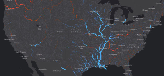
Esri Maps NOAA’s National Water Model
New Real-Time Maps Transform Forecast Data into Vivid Pictures of US River Flows August 25, 2016 – Redlands, California—Smart mapping leader Esri today released a robust collection of web maps
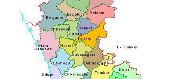
Karnataka to Identify Flood-prone Areas With New Maps and Geo-apps
Karnataka, India – According to recent news by the ET Tech, the Karnataka State Natural Disaster Monitoring Centre (KSNDMC) has initiated an exercise to develop high-resolution contour maps for Bengaluru

Location Powers Workshop to Advance Geospatial applications of Big Data
The Open Geospatial Consortium (OGC®) has announced its Location Powers: Big Data workshop, occurring on Tuesday 20th September in Orlando, Florida. The Location Powers: Big Data workshop will bring together
Hexagon Geospatial Partners with eGIS Associates
eGIS Associates to Provide ERDAS IMAGINE, ERDAS APOLLO Implementation and Training 18 August 2016 – We’re excited to announce that Hexagon Geospatial is partnering with eGIS Associates to provide customers with
Geospatial Technology to Achieve 11th Malaysia Plan
Geospatial technology will play a crucial role in helping agencies achieve the goals set out in the 11th Malaysia Plan (RMK11), according to a panel of Malaysia’s most influential industry

A High-Accuracy Solution for Forest Management
SuperGIS Webinar: A High-Accuracy Solution for Forest Management Wednesday, 17th August 10:00 AM (GMT+2) Your local time Geospatial technology is changing how everything works, including industries with a long history such
