
Tag "geospatial"

Open Geospatial Consortium Requests Participation in its Marine DWG
The Open Geospatial Consortium (OGC®) is calling for public participation in its newly-established Marine Domain Working Group (Marine DWG). The Marine DWG was established to address applicability of the OGC

Are you building the next Pokemon Go? Apply to Geovation now to secure funding for your GeoTech start-up
Geovation, an Ordnance Survey (OS) initiative supporting corporations, SMEs, start-ups and individuals using geospatial technology and data to create innovative new products and services, invites applications for the next batch of
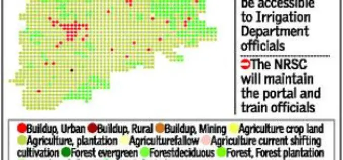
Telangana Goes for Geo-tagging With the Help of NRSC and ICRISAT
According to recent news by The Hindu, soon the citizens, farmers, administrators and policy makers can gain access to information about water availability and cropping pattern in all irrigation systems
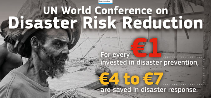
Sendai Framework for Disaster Risk Reduction
The Sendai Framework for Disaster Risk Reduction 2015-2030 provides a new global approach to disaster risk management policy and operations. In June 2016, the European Commission published an action plan
Journal of Geography Article Earns National Council for Geographic Education Accolade
Esri Education Manager Tom Baker Co-Authors Best Article for Geography Program Development Redlands, California—A joint effort from Esri Education manager Tom Baker and a research group of seven university faculty

Two UN Agencies Adopted Geospatial Technologies to Protect Cultural Heritage
Two United Nations agencies (UNOSAT and UNITAR) have signed an agreement to protect cultural and natural heritage sites by using the latest geospatial technologies, including a satellite imaging system. The

DigitalGlobe to Announce Second Quarter Financial Results on July 28, 2016
WESTMINSTER, Colo.–(BUSINESS WIRE)–Jul. 14, 2016– DigitalGlobe, Inc. (NYSE: DGI), a leading global provider of commercial high-resolution earth observation and advanced geospatial solutions, will announce its second quarter 2016 financial results

Singapore Housing & Development Board Leverages Geospatial Technology for Land Use Planning
Since land-use planning is vital in a land-scarce Singapore, the republic’s Housing & Development Board (HDB) has leveraged Geographic Information System (GIS) technology in its Integrated Planning and Analysis system
EMSA Expands Use of RADARSAT-2 Information for Maritime Applications
Richmond, BC – MacDonald, Dettwiler and Associates Ltd. (“MDA” or the “Company”) (TSX: MDA), a global communications and information company, has recently (July 13, 2016) announced that it has signed

25 Years Ago – Europe’s First Earth Observation Satellite Was Launched
• First European radar satellite ERS-1 revolutionised satellite Earth observation by revealing never before seen details • ERS satellite programme laid the foundations for modern radar satellite technology and applications
