
Tag "Mapbox"

Aspectum Adds Arc Visualization to Its Features
Aspectum, a cloud platform for map-based visualization and analytics, releases a new arc visualization display as part of its growing array of features. The main purpose is to show data
Mapbox Launches Global Reality-Grade AR Location Platform
BARCELONA, Spain, Feb. 26, 2018 /PRNewswire/ — As static 2D maps fade away with the bezels of mobile phones, the future interfaces for navigation and gaming exist in augmented reality. App developers need

Mapbox Acquires Fitness AR to Deepen its Focus on Augmented Reality
Team behind top AR app will lead rapidly expanding Mapbox team focused on design and developer innovation SAN FRANCISCO, Dec. 1, 2017 /PRNewswire/ — Mapbox, the mapping and location platform for developers, today
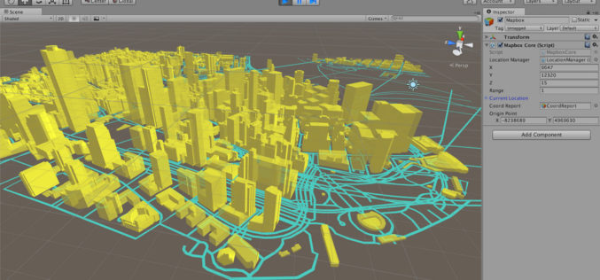
Mapbox Announces Unity SDK
Nov 10, 2016 – Today Mapbox has announced the new Unity SDK giving developers direct access to Mapbox from within Unity, bringing the full spectrum of Mapbox API’s to location-based

Mapbox Added 3D features in Mapbox GL JS
Mapbox added 3D features to Mapbox GL JS to take your maps to new heights! With the new extrusion properties, we can render 3D buildings/3D visualizations, visualize elevation profiles, build
Boundless Exchange 1.0 is Now Available!
Your Open Portal for Spatial Collaboration Boundless Exchange 1.0, a GIS content management platform powered by open source technology, is now available. Boundless Exchange enables spatial and mapping capabilities via
Boundless Releases OpenGeo Suite 4.8
Newest Version Includes Support for Mapbox Vector Tiles, NetCDF for Atmospheric Data, and Improved Rendering Support Boundless, the leader in commercially supported, open source, geospatial software, has released OpenGeo Suite

Download Free Landsat 8 Imagery from the Amazon Web Services Cloud
Amazon has announced the availability of Landsat on Amazon Web Services. Under this program, Amazon will host 1 petabyte of Landsat imagery from USGS on the Amazon Web Services Cloud. You

Introducing the MapBox Surface API
Mapbox Surface API: it’s a remarkable new way to access raw data behind a map. Using Mapbox Vector Tiles, the Surface API can look at elevation profiles to crime indices

Mystery Deepens As Search Area Expands For Malaysia Airlines Flight MH370
It has been 12 days to the missing Malaysia Airlines flight MH370 since March 8. The search for Flight MH370 has now been expanded deep into the northern and southern hemispheres.
