
Tag "mapping"

PhD In ecosystem Service Mapping at ETH Zurich
The Institute for Spatial and Landscape Development, ETH Zurich is looking for a PhD student in ecosystem service mapping. The PhD student will be part of the EU Horizon2020 ECOPOTENTIAL project,
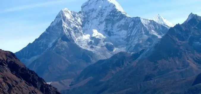
Mount Everest Moved 3 cm, Height Not Affected By Nepal Earthquakes
Beijing: Mount Everest moved three cms during the recent devastating earthquakes in Nepal but contrary to earlier reports the height of world’s tallest mountain has not been affected, Chinese official monitoring

FEMA Release Guidelines for Coastal Flood Hazard Analysis and Mapping
The U.S. Federal Emergency Management Agency has issued Guidelines for Coastal Flood Hazard Analysis and Mapping for the Pacific Coast of the United States. FEMA’s mission is to support citizens and
EPA has Launched Environmental Mapping Tool
United States Environmental Protection Agency (EPA) has launched a new environmental justice (EJ) mapping and screening tool called EJSCREEN. It is based on nationally consistent data and an approach that
FOSS4G Europe Annonce Conference Program
The second edition of the FOSS4G Europe Conference will be held at Politecnico di Milano in Como, Italy, from July 15th to 17th, 2015. A day of workshops will precede

md4-1000 from Microdrones Reviewed By the Geo-matching Community
The Geo-matching.com website features a selection of the most important geomatics equipment, including UAS for Mapping and 3D Modelling. At www.geo-matching.com, you can compare product specifications and read users’ reviews

Aibot X6 from Aibotix Reviewed by the Geo-matching Community
The Geo-matching.com website features a selection of the most important geomatics equipment, including UAS for Mapping and 3D Modelling. At www.geo-matching.com, you can compare product specifications and read users’ reviews

New Mapping Agreement to Benefit United Kingdom and Ireland Location Data Users
A new three party agreement between Ordnance Survey (GB), Ordnance Survey Ireland (OSi) and Land and Property Services (LPS) Northern Ireland is set to improve access and availability of mapping services for
The 5 Most Viewed UAVs for Mapping and 3D Modelling on Geo-matching.com
The Geo-matching.com website features a selection of the most important geomatics equipment, including UAS for Mapping and 3D Modelling. At www.geo-matching.com you can compare product specifications and read users’ reviews
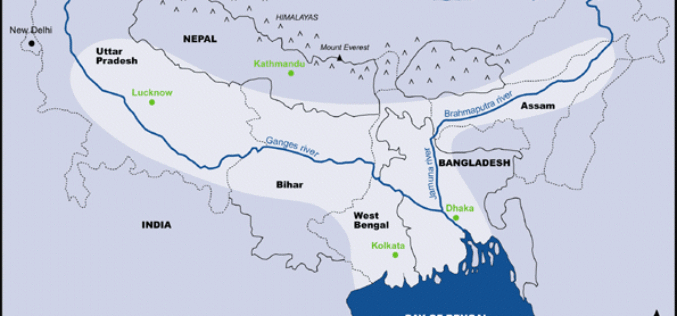
Ganga-Bramhaputra Basin Mapped In First of Its Kind Study
The Ganga-Bramhaputra Basin together store around 960 cubic km of water, researchers have claimed in a first of its kind study after mapping the rivers, and said it will help
