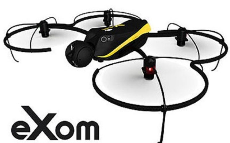
eXom Ready For Take-Off — sensefly’s Intelligent Mapping And Inspection Drone Now Available To Pre-Order
senseFly confirms release timings & technical specifications of its sensor-rich, multi-imaging rotary drone at Unmanned Systems 2015 (Hall B2, Booth 519)
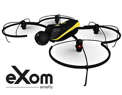 Unmanned Systems 2015, Atlanta, May 5, 2015 – Swiss professional drone maker, senseFly, today launches the eXom, its highly-anticipated quadcopter UAS for mapping and inspection. The eXom is available to pre-order immediately and ships this summer.
The eXom is a uniquely sensor-rich system. Developed by experts working across numerous fields of robotics, this lightweight quadcopter offers professionals such as civil engineers and land surveyors the situational awareness, imaging flexibility and durability they need to complete challenging tasks safely, accurately and efficiently.
“We believe the eXom’s level of application-focused technology is unique in the civilian drone market,” said Antoine Beyeler, CTO and co-founder of senseFly. “This platform tightly integrates several one-of-a-kind features, such as TripleView imaging, advanced situational awareness and full flight mode flexibility—to provide inspection and mapping professionals with the functionality they desire from a rotary system.”
eXom is a future-ready platform with a quad-core computer onboard. Like senseFly’s fixed-wing drones, it offers users ever-evolving performance through regular software updates, adding the latest drone tech innovations to keep the eXom at the cutting edge for years to come.
What’s more, eXom’s low take-off weight of 1.7 kg (3.7 lb) ensures its users will, in many countries, have less flight authorisation paperwork to deal with than those who use heavier systems.
Uniquely Sensor-rich
The eXom contains a rich array of advanced integrated sensors. These work together to provide the user with full situational awareness and support obstacle avoidance:
- Five ‘navcam’ vision sensors allow the operator to see in the direction the drone is moving, automatically via its flight control software, without needing to turn the system’s TripleView camera head. This technology is unique in such a lightweight UAS, similar to the visual parking sensors in modern cars, but brought into a 3D flight environment.
- Five ultrasonic proximity sensors work in harmony with eXom’s navcams to ensure the operator always knows the drone’s distance from nearby objects. (The drone’s shock-absorbent carbon fibre shrouding is also always on hand to protect its rotors in case of surface contact.)
- Numerous other sensors, including inertial measurement units, barometers, magnetometers, GPS and magnetic encoders, maximise the drone’s stability and safety.
TripleView Imaging
In another civilian drone first, eXom’s autopilot-controlled TripleView camera head enables the user to view and record three different types of imagery during a single flight without needing to land to change cameras:
- HD video
- Ultra high-resolution stills
- Thermal still/video Since the TripleView head faces forwards, eXom can fly up close to target structures such as building walls and dams to achieve sub-millimetre data resolutions. Plus, thanks to the head’s 270° vertical field of view, users can document objects positioned directly above and below the drone; crucial for tasks such as bridge and roof inspections.
Full Flight flexibility
eXom offers a flight mode to suit every project:
- Autonomous mode — perfect for mapping projects. First, create a flight plan using eMotion X’s mission blocks. eXom then launches, flies, acquires georeferenced imagery and lands itself.
- Interactive ScreenFly mode — this streaming video mode is perfect for live inspection tasks. Simply use the supplied joypad to navigate and orientate the drone via computer screen. This mode includes flight assistance features such as cruise control and distance lock.
- Or stay flexible… create a flight plan, launch in Autonomous mode, then ‘go live’ on demand.
- No matter which mode is activated, RC-based manual control always remains available as a backup function and for experienced pilots.
About senseFly:
At senseFly we develop and produce autonomous, ultra-light drone systems for civilian applications. Safe and easy to use, these advanced data collection tools are employed around the world by professionals working in surveying, agriculture, GIS, mining and humanitarian aid. senseFly was founded by a team of robotic researchers in Switzerland in 2009 and quickly became the industry leader in mapping drones. Today we continue to lead the way in developing situationally aware, environmentally-friendly drones that enable professionals to make better decisions. For more information, visit www.sensefly.com or follow us on Twitter, LinkedIn or Facebook.