
Tag "navigation"
Google Maps Adds Real-time Location Sharing of Trips
Google Maps has just unveiled a new real-time location sharing feature that allows dear ones to share their location with your Google contacts, or even share with friends and family

Trimble Changes Name to Reflect Company’s Technology Evolution
Completes Delaware Reincorporation SUNNYVALE, Calif., Oct. 3, 2016 Trimble (NASDAQ: TRMB) announced today that is has formally changed its company name from Trimble Navigation Limited to Trimble Inc. In addition,
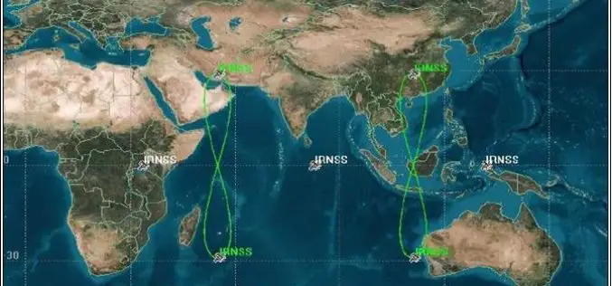
PSLV-C33 Successfully Launches India’s Seventh Navigation Satellite IRNSS-1G
Apr 28, 2016 – In its thirty-fifth flight (PSLV-C33), ISRO’s Polar Satellite Launch Vehicle successfully launched the 1425 kg IRNSS-1G, the seventh satellite in the Indian Regional Navigation Satellite System (IRNSS)

Seminar on Geodesy, Navigation and Positioning
Aalto University is a new university with over a century of experience. Created from a high-profile merger between three leading universities in Finland – the Helsinki School of Economics, Helsinki

Play Pac Man with Google Maps on Your Streets
Recently Google Maps has launched “Pac Man” in Google Maps. Team at Google Maps has coded a web application that lets users turn any city into classic arcade of game with hungry

Two New Satellites Join The Galileo Constellation
28 March 2015 – The EU’s Galileo satellite navigation system now has eight satellites in orbit following the launch of the latest pair. Galileo 7 & 8 lifted off at

IRNSS-1D, 4th Satellite of IRNSS Constellation Launched Successfully
Today (Mar. 28, 2015) ISRO’s Polar Satellite Launch Vehicle, PSLV-C27, successfully launched IRNSS-1D from Satish Dhawan Space Centre, Sriharikota. The satellite is one among the seven of the IRNSS constellation

GEOVISION Utilizes SuperGIS for Maritime and Land GIS Planning
Supergeo Technologies Inc., the leading GIS software and solution provider, announces that GEOVISION, Nouvelle-Calédonie, selects cross-platform SuperGIS series products, SuperGIS Desktop, SuperSurv and SuperVeyor, to elevate its maritime and land

GAGAN to Save Lives at Unmanned Railway Crossings
The Indian Railways is in talks with the Indian space agency on the possibility of using GPS-aided geo-augmented navigation (GAGAN) for safety at unmanned railway crossings, said a top ISRO official. The

OGC Adopts IndoorGML Standard for Encoding Indoor Navigation Data
The Open Geospatial Consortium (OGC) membership has approved the OGC IndoorGML Encoding Standard. This OGC standard specifies an open abstract data model and XML schema for indoor spatial information. The
