Credit: Rail News
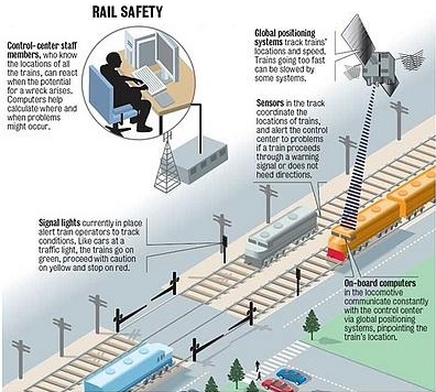
The Indian Railways is in talks with the Indian space agency on the possibility of using GPS-aided geo-augmented navigation (GAGAN) for safety at unmanned railway crossings, said a top ISRO official.
The GAGAN system is a regional satellite based augmentation system developed mainly to assist landing of aircrafts accurately.
Presenting his maiden railway budget Thursday, union Rail Minister Suresh Prabhu, speaking on the safety at unmanned railway crossings, said: “In the short-term, RDSO (Research Designs and Standards Organisation) has been asked to develop a suitable device with reliable power supply system based on theft-proof panels/batteries in consultation with Indian Space Research Organisation (ISRO), using geospatial technology for providing audio-visual warning to road users at unmanned level crossings.”
“Further, a radio-based signal design project has been taken up with IIT Kanpur for warnings at unmanned level crossing,” Prabhu added.
Queried about that, ISRO chairman A.S. Kiran Kumar told IANS: “Discussions are in progress with the Indian Railways for using GAGAN based system and software.”
He said that using the GAGAN system, the train with the necessary receivers will know the location of the level crossings and a warning signal can be sent.
The warning signal could be activating the train’s hooter automatically.
“The system is developed mainly for the safety of lives,” Kumar said.
He said a pilot project was successfully carried out at an unmanned level crossing in Gujarat.
Kumar said GAGAN receivers could be located in the train engine or guard’s cabin.
According to him, the Directorate General of Civil Aviation (DGCA) has recently certified the usage of GAGAN system for landing of aircrafts.
-IANS