
Tag "NDVI"

Upcoming Changes to USGS ESPA Processing and Output options of Surface Reflectance Climate Data
Today I received an email from USGS as a notice of changes coming soon to the USGS EROS Science Processing Architecture (ESPA) interface (https://espa.cr.usgs.gov/) , that allows you to process Landsat 4/5 Thematic
Why does NDVI, NDBI, NDWI Ranges From -1 to 1?
The indices calculated from satellite imageries such as the Normalized Difference Vegetation Index (NDVI), Normalized Difference Built Index (NDBI) and Normalized Difference Water Index (NDWI) have indices values ranging from
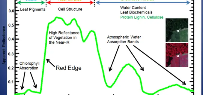
Vegetation Indices
Vegetation Indices has proved to have an extremely wide (and growing) range of applications. It is used to monitor vegetation conditions and therefore provide early warning on droughts and famines.

Maximum Value Composite Images (MVC’s): A solution for Cloudy Image to calculate NDVI
When the satellite views an area at any one time, a large part of the image may be cloud, which has a very low NDVI (approximately 0.002). This gives no
