
Tag "UAS"
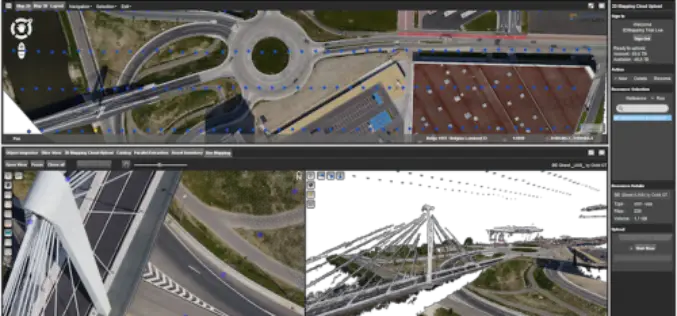
Orbit GT Releases UAS Mapping v17.1 With Cloud Upload Feature at UAV EXPO, Brussels
Orbit GT releases v17.1 of its UAS Mapping desktop product including the all-new Upload to the Cloud feature. It is available for download today from our website www.orbitgt.com. “This upgrade includes

30 Years of Success Leads DAT/EM to Virtual Reality and UAS
30 Years of Success Leads DAT/EM to Virtual Reality and UAS Anchorage, Alaska, USA. May 10, 2017- In 1987, a group of photogrammetric professionals envisioned a product that would bridge the

Icaros Releases Version 5.0 of OneButton™ Drone Image Processing Software
Icaros Releases Version 5.0 of OneButton™ Drone Image Processing Software Free 30-Day Trial FAIRFAX, Virginia, USA, 15 May 2017 – Icaros Inc., a leading provider of aerial imaging software, is pleased
Airbus Creates New Commercial Drone Services Start-up “Airbus Aerial”
– Launches U.S. base and business, headquartered in Atlanta, Georgia – Starts operations with imagery services fusing drones, satellite images, and software to bring deeper insights to commercial customers –

PrecisionHawk Launches Free PrecisionMapper Software for Drone Mapping
Now drone operators can stitch an unlimited number of photos, create maps without resolution limits and run algorithms to analyze their data for free PrecisionHawk, a leading commercial drone and
senseFly Corridor Solution Boosts Efficiency of Linear Mapping Projects
Today’s new combined hardware/software release makes assessing linear assets with UAS easier and less data-intensive than ever before senseFly, the world’s leading producer of mapping drones, today announces senseFly Corridor,

Drones in Agriculture and Hands-On Drone-to-GIS Workflows
Hands-On Drone-to-GIS Workflows Sponsored by the Michigan State University Institute of Agricultural Technology, in coordination with RS&GIS and Northwest Michigan College. This unique and comprehensive, instructor-led training course is taught
EdgeData and Harris Corporation to Collaborate on Electric Utility Asset Inspection and Management Solutions
EdgeData’s inspection infrastructure, powered by Harris Corporation’s geospatial analytics, will modernize the electric utility industry’s asset inspection and management practices. (Grand Forks, N.D.) —February 17, 2017 – EdgeData LLC and
Kongsberg Geospatial & AirMap Deliver Real-Time Airspace Awareness and Tools for Drone Flight Beyond Visual Line of Sight
Ottawa, CA: Kongsberg Geospatial, an Ottawa-based developer of real-time, mission critical, geospatial visualisation software, and AirMap, the leading airspace management platform for drones, announced today that they will be delivering

Centrik Helps Business Take Off for Self-regulating UAS Operators
UAS operators concerned by growing calls over regulation of the sector can now hold the key to successful self-regulation, thanks to operational management system Centrik. Already used by airlines, operators,
