Weed Mapping in Maize Fields Using Unmanned Aerial Vehicle (UAV) Images
Weed Mapping in Early-Season Maize Fields Using Object-Based Analysis of Unmanned Aerial Vehicle (UAV) Images
Today I was doing google about UAV and I came across a awesome work by José Manuel Peña et. al. . I am sharing with you important outcomes of the study. You can read and download full paper at the link provided at the last of the post.
Many agricultural crops require the use of herbicides as essential tools for maintaining the quality and quantity of crop production. Currently, the cost of herbicides accounts for approximately 40% of the cost of all the chemicals applied to agricultural land in Europe. Associated environmental and economic concerns have led to the creation of European legislation on the sustainable use of pesticides. This legislation includes guidelines for the reduction in applications and the utilization of adequate doses based on the degree of weed infestation. Both components are integrated in the agronomical basis of the precision agriculture principles and especially of site-specific weed management (SSWM).
This consists of the application of customized control treatments, mainly herbicides, only where weeds are located within the crop field in order to use herbicides and doses according to weed coverage.
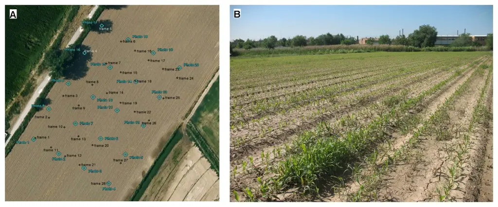
Aerial view of the experimental field (a), showing the centers of the UAV aerial images in blue and the sampling points in black (see section 2.4), and in-field photograph of the study site (b), showing the maize rows and some patches of weed infestation.
SSWM typically uses new technologies to collect and process spatial information on the crop field. Remote sensing technology can play a role here as an efficient and repeatable method to obtain crop field information related to weed infestation. The analysis of remote images captured with aircraft and satellite platforms has resulted in numerous examples of weed mapping in late growth stages, although in many weed–crop systems, the optimal treatment time is early in the growth season when weeds and crops are in their seedling growth stages. However, discriminating small seedlings with airborne and satellite imagery is problematic due to the insufficient spatial resolution of these images. This difficulty might be now overcome using the new generation of remote platforms known as unmanned aerial vehicles (UAV) or unmanned aerial systems (UAS).
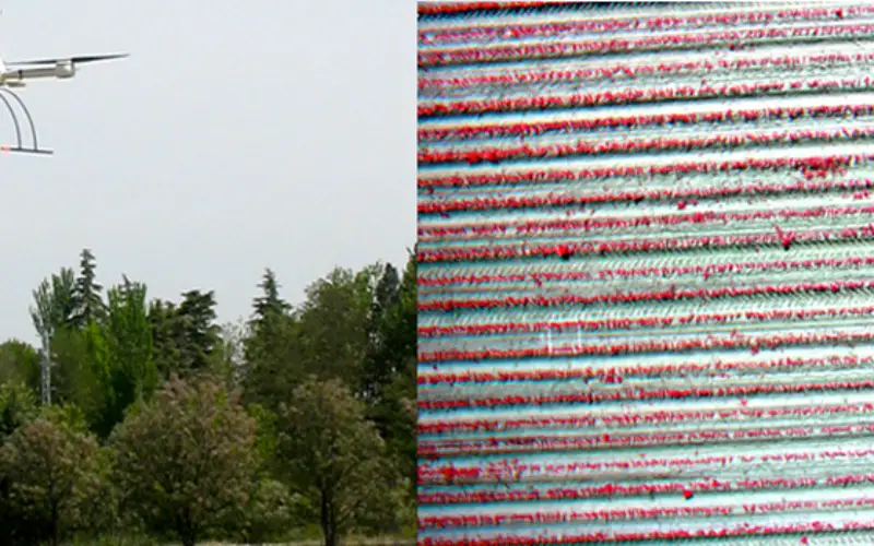
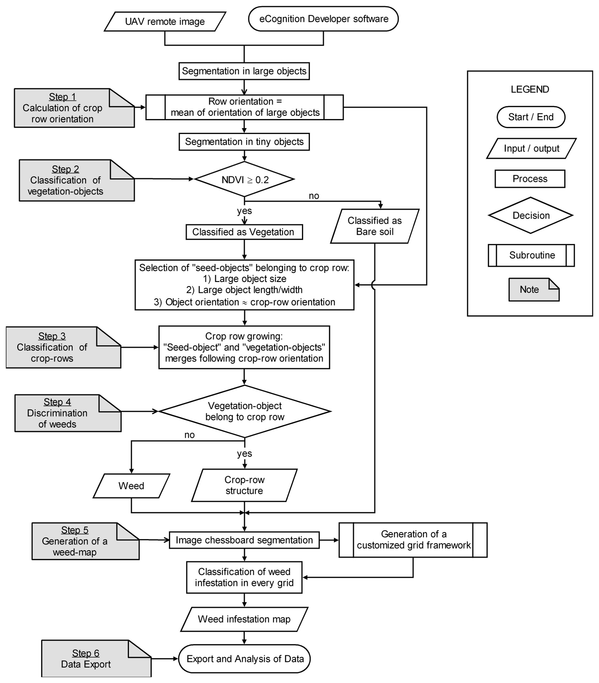
The use of remote imagery captured by unmanned aerial vehicles (UAV) has tremendous potential for designing detailed site-specific weed control treatments in early post-emergence, which have not possible previously with conventional airborne or satellite images. A robust and entirely automatic object-based image analysis (OBIA) procedure was developed on a series of UAV images using a six-band multispectral camera (visible and near-infrared range) with the ultimate objective of generating a weed map in an experimental maize field in Spain.
The OBIA methodology first identifies spatially and spectrally homogenous units (objects) created by grouping adjacent pixels according to a procedure known as segmentation and next it combines spectral, contextual and morphological information to drastically improve image classification results. In this process, the definition of the row structure formed by the crop is essential for further identification of plants (crop and weeds) because the position of each plant relative to the rows might be the key feature used to distinguish among the weeds and crop plants.
A model md4-1000 quadrocopter UAV (microdrones GmbH, Siegen, Germany) with vertical take-off and landing capabilities was used to collect the remote images.
Results and Discussion
An advantage of the OBIA procedure, compared to traditional pixel-based methodologies, is its ability to compute multiple data and statistics derived from the image analysis and classification.
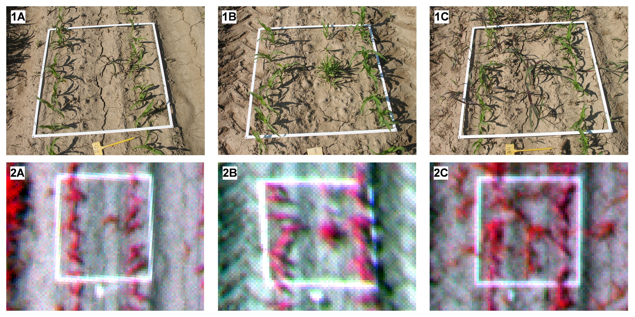
The algorithm developed in this study identified and counted the rows in the training images with 100% accuracy and only had minor errors in classifying short rows located in the corners of some testing images.
The accuracy of the methodology was evaluated by comparing the estimation of weed coverage derived from the UAV image classification and the values observed in the on-ground sampling photographs.
The combination of ultra-high-spatial-resolution UAV remote images and the OBIA procedure developed in this study permits the generation of weed maps in early maize crops for use in planning the application of in-season weed control measures, which has not been possible previously with traditional airborne or satellite images. This technology can help in the implementation of the European legislation for the sustainable use of pesticides, which promotes reductions in herbicide applications and the utilization of doses appropriate to the levels of weed infestation present.
Read and Download Full Paper in PDF