
Archive
Qatar University Begins Digital Archiving
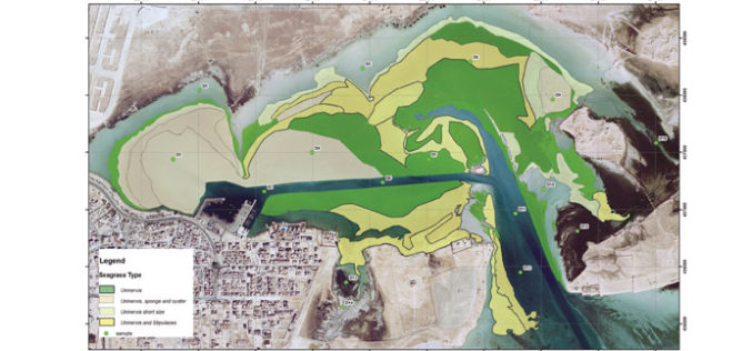
In a recent news by Gulf Times, Remote Sensing and Geographic Information Systems (GIS) Unit in the Environmental Studies Centre (ESC) at Qatar University has initiated the course of action to digitally

Looking Down from 600 km Above the Earth’s Surface with HD Video
Looking Down from 600 km Above the Earth’s Surface with HD Video – It will be possible to see the world is real time…By Skybox Imaging
PR: Topcon TopNETlive fastest growing GNSS network service in North America
LIVERMORE, Calif., USA/ CAPELLE A/D IJSSEL, The Netherlands – March 5, 2014 – Topcon Positioning Group announces the expansion of its TopNETlive network service into nineteen states and five Canadian provinces, making

NOAA’s National Geodetic Survey : 2014 GPS on Bench Marks Campaign
NGS encourages anyone with survey-grade Global Positioning System (GPS) receivers to join the 2014 GPS on Bench Marks Campaign, a National Surveyors Week (March 16-22) event to raise awareness about professional surveying

Built-in GPS for Mercedes Benz Owners to Locate Their Car with Smartphone
In a recent news, Mercedes Benz comes with a similar technology as of Apple’s ‘Find My iPhone’ which uses the device built-in GPS Sensor to locate their smartphone. The technology
RFP Supply of GIS Based Optical Fiber Cable Network Management System (GOFNMS)
Procurement, Supply, Installation, Testing And Maintenance Of GIS Based Optical Fiber Cable Network Management System (GOFNMS) And Accessories For Exclusive Optical NLD Backbone and Access Routes and Site Preparation Requirements

EoI for Baseline Survey & Mapping of Food Business
Terms of Reference for Baseline Survey & Mapping of Food Business units in Karnataka State under Food Safety and Standards Act 2006 The Government of India with an objective to
3D Terrain Mapping
This video demonstrations a Silverlight web application rendering 3D terrain using Esri’s Silverlight SDK and Balder, a 3D graphics engine.

What’s New in ENVI 5.1?
Yesterday I got my first hand on experience with the ENVI 5.1, image processing software. Loaded with lots of many new features and with a new user interface. The
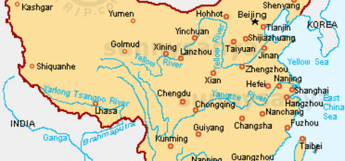
China Gathers Data of its 10, 500 Islands
In recent news, China has gathered detailed topographic topographic information and images of all its 10, 500 islands using remote sensing technology. It took three years of work by the aviation
