
Archive
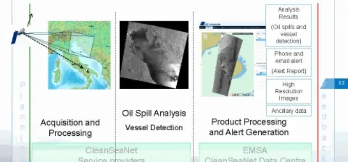
CleanSeaNet:Near Real Time Service to Protect Sea
In a wake to protect our sea, to safeguard marine habitat, serious risks of ecological damage and socio-economic losses, the European Maritime Safety Agency (EMSA) has started a satellite-based pan-European oil spill and

Emergency Mapping Guidelines
The aim of the guidelines is to help support an effective exchange and harmonization of emergency mapping efforts leading to improved possibilities for cooperation amongst involved Emergency Mapping Organizations. This
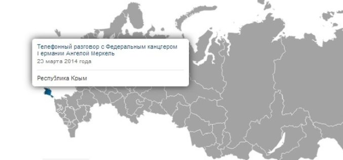
Google Mapmakers to Mark Crimea as Russian Territory
MOSCOW, April 11. /ITAR-TASS/. Google Russian-language mapmakers have marked Crimea as part of Russia. The world’s largest search engine has updated its mapping services maps.google.ru and maps.google.com, drawing a new state line between Crimea

Taipei City Government Launched a Online Historical 3D Map
In recent news by Liberty Times, The Department of Urban Development of Taipei City Government has launched a web based historical 3D map. The application facilitates citizens to compare the

NASA’s Double Pulse Laser- LiDAR to Study CO2
In recent news, a team of engineers at NASA Langley Research Center has developed world’s first double-pulsed laser system that make measurements of CO2 with highest degree of accuracy, all

M.Sc. (Geospatial Science & Technology) Programmes at JNTU Hyderabad
JNTU has been deemed an autonomous one after Act No 30 of the approval of the Andhra Pradesh Legislature known as the Jawaharlal Nehru Technological Universities Act, 2008 which came

RFP: Acquisition, Processing & Interpretation (API) of Airborne Magnetic Data
Oil India Limited (OIL), a Government of India Enterprise and premier oil company in India is engaged in exploration, production and transportation of crude oil & natural gas having its
RFP: Detailed Survey for the Construction of 400kV DC Evacuation Line for a Distance of about 20Km in Bellary District.
Karnataka Power Transmission Corporation Limited has invited tender for “Conducting the detailed survey for the construction of 400kV DC Evacuation line, with QUAD Moose Conductor from 400kV ETPS Pooling station to proposed
Esri Geospatial Technology Speeds Analysis for US Army
Ready-to-Use Templates Quickly Deliver Critical Information to the Field April 7, 2014-Redlands, California—Esri has provided a recently revised set of customized templates to the US Army for its Distributed Common Ground
Remote Sensing to Search Minerals for Turkey and Azerbaijan
In recent news, Turkey and Azerbaijan have started a joint program to explore mineral deposits using earth observation satellites. As per the agreement Turkey will build a Remote Sensing laboratory
