
Archive
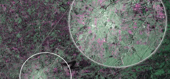
First RADAR Images of Earth by Sentinel-1A Satellite
ESA’s Sentinel-1A, kicked off on April 3, 2014, has delivered its first RADAR images of earth. ESA’s Sentinel-1A satellite will provide the ability of policymakers and service providers to access
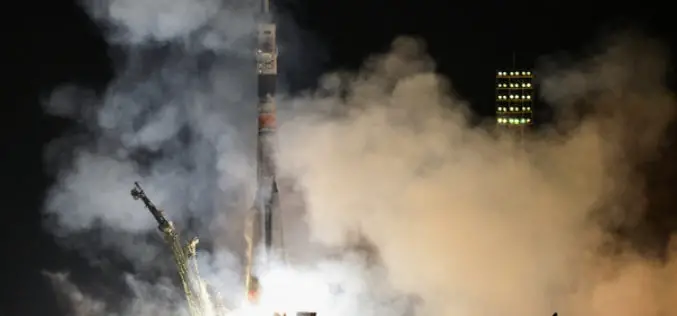
Egyptian Satellite Lift off Successfully from Baikonur
An Egyptian earth observation satellite, Egyptsat was successfuly launched from Baikonur cosmodrone on April 16, 2014. The satellite was on-board to Soyuz-U launch vehicle. Egypsat is equiped with advanced technologies for
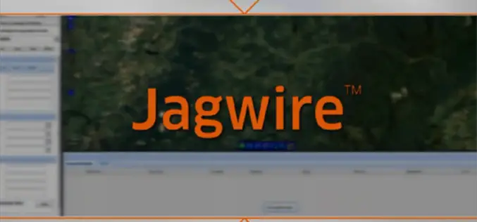
Exelis Jagwire to Support Real-time Full Motion Video Analysis
Jagwire is a web-based software that enables you to use satellite imagery, video, and other contextual geographic data to solve real-world problems.
Exelis Jagwire™ to Support Real-time Full Motion Video Analysis
Integration with MotionDSP Ikena™ software enables faster decision-making for forward-deployed usersROCHESTER, N.Y., April 15, 2014 – Exelis (NYSE: XLS), has combined their web-based Jagwire geospatial data management system with MotionDSP’s Ikena real-time image
Superior Public Bike System with SuperGIS Desktop 3.2
Supergeo Technologies, a leading global provider of GIS software and solutions, assists Kaohsiung City in analyzing superior network, like locations and routes, of the public bike system. The usage efficiency

UNSW -NASA One Week Short Course on Radar Remote Sensing For Postgraduate Students
UNSW -NASA One Week Short Course on Radar Remote Sensing For Postgraduate Students UNSW and NASA/JPL will jointly offer a one-week intensive short-course, GMAT 9606 Radar Remote Sensing (6
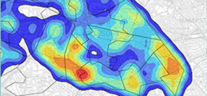
Crime Mapping by Delhi Police to Tackle Crime Against Women
In recent news, in response to a PIL filed by Nandita Dhar through advocate Gaurav Kumar Bansal alleging instances of eve-teasing in Delhi, the Delhi High Court ordered Delhi Police to
Workshop on Satellite Remote Sensing and Applications at UNSW, Australia
Free Workshop on Satellite Remote Sensing and Applications-For UNSW Undergraduate and Postgraduate Students This FREE two-day workshop for UNSW undergraduate and postgraduate students will discuss: the principles of satellite remote
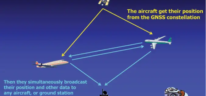
U.S.: By 2020 All Aircraft Must Have GPS Tracking System
In recent news, in take way from recent incident of mysterious disappearance of Malaysian Airlines plane MH 370, The Federal Aviation Administration (FAA) is accelerating the implementation of a system

Scientists Chart Seafloor of One of Earth’s Largest Marine Protected Areas
Apr 15, 2014- On April 11, scientists returned from a 36-day mapping expedition to Papahānaumokuākea Marine National Monument (PMNM) in the remote Northwestern Hawaiian Islands. PMNM is the largest protected area
