
Archive

ICPECDM ’14 – International Conference on Challenges in Disaster Management
ICPECDM ’14 – International Conference on Professional Engineers: Challenges in Disaster Management Sponsored by TEQIP-II SC 1.2 18th-19th December 2014 India is one of the most disaster prone countries of

EOI: TCIL – Establishment of Integrated modern control room with GIS and GPS equipment and Vehicle Tracking System at Varanasi
Pre-bid tie-up for Selection of Partner for “Establishment of integrated modern control room with GIS & GPS equipment and vehicle tracking system at Varanasi” TCIL intends to participate in the tender
Malaysia to Use Geospatial Technology to Strengthen Defence
In recent news, Malaysia’s research agency (Malaysian Institute of Microelectronics Systems – MIMOS) has signed an agreement with Esri to enhance the government’s research efforts in knowledge sharing as well

3D Laser Mapping Helps Preserve Earthquake Prone Buildings in New Zealand
New Zealand based Solutions By Zeal is reaping the rewards of using the ZEB1 hand held laser mapping system to survey buildings at risk from earthquakes or in need of

Webinar: Tools and Technologies for HazMat Planning and Response
Narrative: This webinar is presented by the Department of Homeland Security (DHS) First Responder Group and the National Information Sharing Consortium. The discussion will offer lessons learned, best practices, and
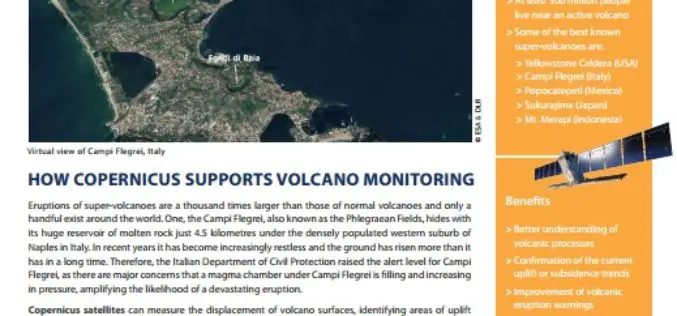
How Copernicus Supports Volcano Monitoring
Eruptions of super-volcanoes are a thousand times larger than those of normal volcanoes and only a handful exist around the world. One, the Campi Flegrei, also known as the Phlegraean
Various APIs in SuperGIS Server 3.2 Improve Customization Flexibility
Supergeo Technologies, the global leading GIS software and solution provider, releases rich JavaScript APIs (Application Programming Interface) to assist SuperGIS Server 3.2 users in customizing plentiful and intuitive map websites.

SuperGIS Supports Orienteering Club Charity Map Projects
Supergeo Technologies, the global leading GIS software and solution provider, announces that Star Vision Ltd., Supergeo Certified Reseller in Hong Kong, Macau and Guangdong, utilizes SuperGIS in a charity map

Workshop by University College Dublin on Key Online Mapping Resources for Irish Data
University College Dublin is one of Europe’s leading research-intensive universities. At UCD undergraduate education, master’s and PhD training, research,innovation and community engagement form a dynamic spectrum of activity. Today UCD

Hexagon Live Webcast: Solutions for Property Appraisers
Hexagon Geospatial has teamed up with industry-leading APEX software and Leica Geosystems to revolutionize your appraisal workflows. Join Hexagon live Webcast Series and learn about a 3-Step Process to Streamlining
