
Archive

TerraGo Webinar: CAD Data in the Palm of Your Hand
CAD Data in the Palm of Your Hand June 23, 2015 12:00 – 12:30 PM ET Join this webinar to learn how to put CAD drawings in the hands of

Mount Everest Moved 3 cm, Height Not Affected By Nepal Earthquakes
Beijing: Mount Everest moved three cms during the recent devastating earthquakes in Nepal but contrary to earlier reports the height of world’s tallest mountain has not been affected, Chinese official monitoring
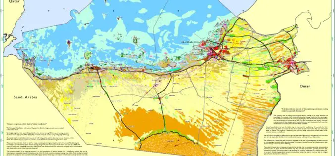
Habitat Mapping to improve Biodiversity and Crisis Management
The Environment Agency-Abu Dhabi (EAD) has completed an ambitious project of habitat mapping (terrestrial and marine), landuse and landcover for the Emirate of Abu Dhabi. The mapping of habitats will help

Highest Peak in North America to be Surveyed
Several agency partners plan to update the height of Mount McKinley this summer A new GPS survey of Mount McKinley, the highest point in North America, will update the commonly

Hyderabad – First City in India to Get Google Street View
The Telangana government has agreed to keep sensitive defence installations in Hyderabad out of Google Street View and the union home ministry is expected to soon give permission for the
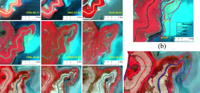
Monitoring Spatial and Temporal Dynamics of Flood Regimes and Their Relation to Wetland Landscape Patterns in Dongting Lake from MODIS Time-Series Imagery
Monitoring Spatial and Temporal Dynamics of Flood Regimes and Their Relation to Wetland Landscape Patterns in Dongting Lake from MODIS Time-Series Imagery – Hu, Y.; Huang, J.; Du, Y.; Han, P.;
Who Else Want to See World in 3D
Vricon, developed as a joint venture of Saab and DigitalGlobe, Inc., is to produce data rich 3D model of world. DigitalGlobe and Saab will combine their strengths to both support and own Vricon. Saab will

Trimble Introduces New Laser for Interior Construction
SUNNYVALE, Calif., June 10, 2015—Trimble (NASDAQ: TRMB) introduced today the Spectra Precision® LT58 Laser Tool, a new line laser for interior construction ideally suited for acoustic ceiling installations. The LT58

SuperGIS Webinar: Smart Industrial Hazard Management with GIS
Smart Industrial Hazard Management with GIS To avoid chemical accident causes fatal damage of public lives, emergency dispatchers need various resources to plan prevention and response in advanced. Join SuperGIS

FEMA Release Guidelines for Coastal Flood Hazard Analysis and Mapping
The U.S. Federal Emergency Management Agency has issued Guidelines for Coastal Flood Hazard Analysis and Mapping for the Pacific Coast of the United States. FEMA’s mission is to support citizens and
