
Archive
EPA has Launched Environmental Mapping Tool
United States Environmental Protection Agency (EPA) has launched a new environmental justice (EJ) mapping and screening tool called EJSCREEN. It is based on nationally consistent data and an approach that

Global Mapper and GM LiDAR SDKs v16.2 Released with Significant Export Processing Speed Gains
Hallowell, Maine – June 10, 2015 – Blue Marble Geographics (bluemarblegeo.com) is pleased to announce the immediate availability of version 16.2 of the Global Mapper Base Software Development Kit (SDK) along

Michigan Launch Portal for Free Geospatial Data
State of Michigan has launched a portal for citizens to access and download free geospatial data about their state. The data is available for government, business and public use, with
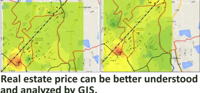
Real Estate Price Distribution Analysis by GIS Technology
Influenced by traditional Chinese thoughts, having own real estate is almost everyone’s life target in Taiwanese community. However, the price has been speculated to unreasonable high level, some research teams

Talk: From SAR to spatial data infrastructures – Applied remote sensing at the Chair of Remote Sensing at the Friedrich-Schiller-University Jena
From SAR to spatial data infrastructures – Applied remote sensing at the Chair of Remote Sensing at the Friedrich-Schiller-University Jena, Germany by Carsten Pathe, Jonas Eberle The talk will give

Teledyne Optech and Orbit GT enter partnership for Mobile Mapping software
June 9, 2015 — Teledyne Optech is pleased to announce that it has entered a partnership with Orbit GeoSpatial Technologies to resell their world-class Orbit Mobile Mapping software, giving the
USGS Webinar: Using The National Map Services to Enable Your Web and Mobile Mapping Efforts
USGS Webinar: Using The National Map Services to Enable Your Web and Mobile Mapping Efforts Are you a developer, firm, or organization using mobile or web applications to enable your
FOSS4G Europe Annonce Conference Program
The second edition of the FOSS4G Europe Conference will be held at Politecnico di Milano in Como, Italy, from July 15th to 17th, 2015. A day of workshops will precede

md4-1000 from Microdrones Reviewed By the Geo-matching Community
The Geo-matching.com website features a selection of the most important geomatics equipment, including UAS for Mapping and 3D Modelling. At www.geo-matching.com, you can compare product specifications and read users’ reviews
Esri Joins International Partnership to Enhance Climate Resilience in Developing Countries
Colombia, Ethiopia, and Bangladesh to Harness ArcGIS Platform to Achieve Long-Term Sustainability Redlands, California—In a next phase of support of The White House Climate Action Plan, Esri will donate its best-of-breed
