
Archive
Amnesty International Launches Online Tool Mapping Exposing Israeli Attacks in Gaza
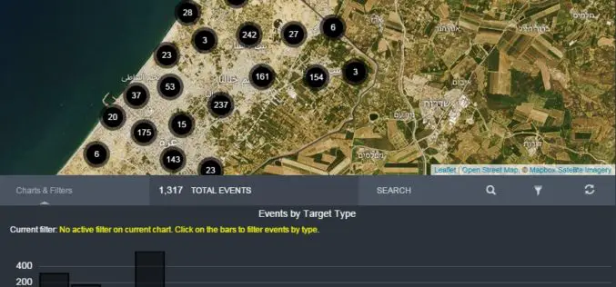
Amnesty International and Forensic Architecture has launched an investigative online tool mapping Israeli attacks in Gaza during the conflict of July and August 2014. The mapping tools aimed to push accountability

Avenza Releases Geographic Imager 5.0 for Adobe Photoshop
Powerful geospatial imaging tools now supports Adobe Photoshop CC 2015 Avenza Systems Inc., producers of MAPublisher® cartographic software for Adobe Illustrator® and the popular PDF Maps mobile app, is pleased

India May Soon Have 3D Imagery of Major Cities
3D imagery of buildings and terrain of India’s major cities, including Rashtrapati Bhavan and PMO, could soon be seen in Google Earth with the government contemplating to give permission for

Blue Marble Geographics Announces its 2015 6th Annual User Conference in Arlington, Virginia
Blue Marble Geographics (bluemarblegeo.com) is pleased to announce that the 2015 Blue Marble User Conference (BMUC) will take place in Arlington, VA on Tuesday October 6. This annual event provides

what3words addresses growth by hiring leading UK geocoding expert as new Chief Technology Officer
Gary Gale joins what3words following a career spanning HERE to Ordnance Survey, strengthening the service that gives everyone & everywhere an address – Gary Gale, the British geocoding expert and

EagleView Announces Gold Status within Esri Partner Network
EagleView Technology Corporation, a leading technology provider of aerial imagery, data analytics and GIS solutions, announced that its wholly owned subsidiary, Pictometry International Corp., has obtained gold status within the
UNESCO and UNITAR-UNOSAT Signed an Agreement to Protect Heritage Using Geospatial Technologies
UNESCO and UNITAR (the UN Institute for Training and Research) have signed an agreement to protect cultural and natural heritage sites with the latest geospatial technologies. It was signed at

Los Angeles Department of Transportation Empowers Smart Communities with Esri Web Map
Spatial View of Los Angeles Mobility Network Shows Street Projects, Paving the Way for a People-Friendly Future Redlands, California—A new public web map, built on the Esri ArcGIS platform, shows

New GeoDigital Vegetation Management Calculator Estimates over $1 Billion in Savings for North American Utilities
By moving from human to digital inspections utilities in North America can conservatively save $1 billion, reduce risk of vegetation-related outages whilst improving efficiency, safety and enabling compliance GeoDigital, a
Institute of Ecology and Geobotany, Yunnan University Imports GIS for Academics
Supergeo Technologies, the leading GIS software and solutions provider, announces that Institute of Ecology and Geobotany, Yunnan University imports GIS by selecting GIS Learning CD to spread and educate the
