
Archive

Geo-matching.com Updates Total Stations Category
Geo-matching.com has recently updated the specifications of the Total Stations product category. Topcon and Trimble are the first suppliers that have updated the specifications for some of their total stations.
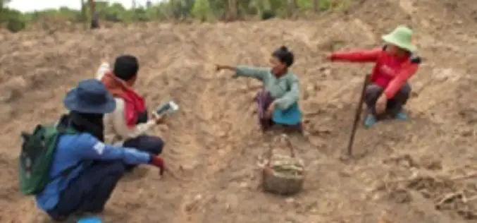
Mobile Mapping App Helps Humanitarian Organizations Clear Landmines In War-Torn Countries
Spatial Networks, a St Petersburg, FL based technology firm, has discovered a new application for Fulcrum, its mobile mapping platform – helping humanitarian organizations like HALO Trust identify landmines in
4Dmapper to Store, Deliver and to Share Geospatial Data
4Dmapper is a web based geospatial product. If you are thinking that it is same as Google Earth or Bhuvan; NO, 4Dmapper is a rich, purely browser based 3D environment

OGC requests comment on extension that integrates OGC WCS Standard with JPEG 2000 and JPIP
Members of the Open Geospatial Consortium (OGC®) request comments on the OGC® Web Coverage Service 2.0 Interface Standard – JPEG2000/JPIP Coverage Encoding Extension – abbreviated as “JPEG2000/JPIP-Coverage”. This candidate OGC

Vienna University of Technology Releases OPALS v 2.1.5 – A Airborne Laser Data Processing Software
The Department of Geodesy and Geoinformation, Vienna University of Technology announces the release of OPALS version 2.1.5. OPALS stands for Orientation and Processing of Airborne Laser Scanning data. It is a
ISPRS Releases The International Archives of the Photogrammetry, Remote Sensing and Spatial Information Sciences
The International Archives of the Photogrammetry, Remote Sensing and Spatial Information Sciences is the series of proceedings published by the International Society of Photogrammetry and Remote Sensing (ISPRS). The Archives
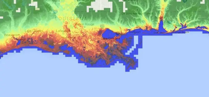
Accuracy Comparison of Publicly available DEMs and LiDAR DEM for Coastal Flood Risk Assessments
Coasts are experiencing the adverse consequences of hazards related to climate change and sea level rise and will be exposed to increasing risks of coastal flooding. Ten percent of the
Increase the Return on Your GIS Investment with GIS-Lite Applications
Increase the Return on Your GIS Investment with GIS-Lite Applications July 14, 2015 12:00-12:30 PM ET Deliver self-contained, interactive maps and lightweight GIS applications available to all end users with
Insights to SuperGIS Server 10
Supergeo is going to upgrade all the products to a new level, the 10 series, including SuperGIS Server. The most exciting thing in SuperGIS Server 10 is its integration of

European Union and China Have Signed a Research Deal on Remote Sensing
European Union and China have signed a new collaborative research arrangement in the area of remote sensing. The deal, which emerged during the Europe-China summit, involves Europe’s Joint Research Centre (JRC) and
